Caminreal elevation
Caminreal (Aragon, Provincia de Teruel), Spain elevation is 925 meters and Caminreal elevation in feet is 3035 ft above sea level [src 1]. Caminreal is a seat of a third-order administrative division (feature code) with elevation that is 322 meters (1056 ft) bigger than average city elevation in Spain.
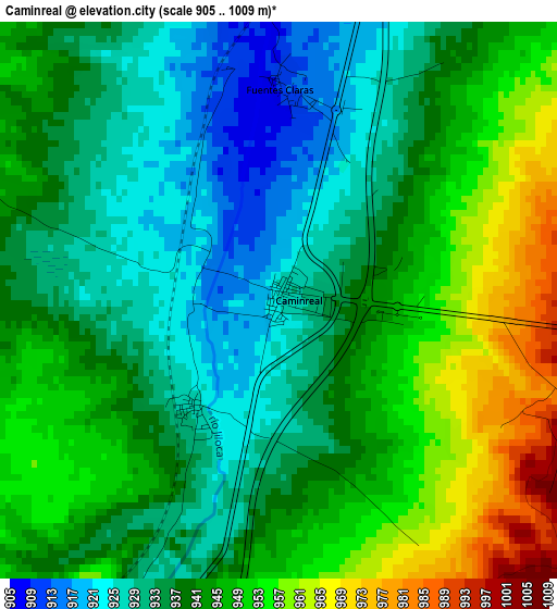
Below is the Elevation map of Caminreal, which displays elevation range with different colors. Scale of the first map is from 905 to 1009 m (2969 to 3310 ft) with average elevation of 940.7 meters (=3086 ft) [note 1]
These maps also provides idea of topography and contour of this city, they are displayed at different zoom levels. More info about maps, scale and edge coordinates you can find below images.
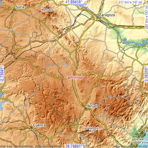
| \ | Map #1 | Topo.Map |
| Scale [m] | 905..1009 m | × |
| Scale [ft] | 2969..3310 ft | × |
| Average | 940.7 m = 3086 ft | × |
| Width | 7.39 km = 4.6 mi | 236.6 km = 147 mi |
| Height | 7.39 km = 4.6 mi | 236.6 km = 147 mi |
| ↑Max Latitude | 40.872069° | 41.89418° |
| Latitude at center | 40.83883° | 40.83883° |
| ↓Min Latitude | 40.805575° | 39.76641° |
| ← Min Longitude | -1.368105° | -2.73041° |
| Longitude center | -1.32416° | -1.32416° |
| →Max Longitude | -1.280215° | 0.08209° |
Nearby cities:
Cities around Caminreal sort by population:
• Calamocha elevation 891 m
9.2 km,  14°
14°
• Monreal del Campo 946 m
6.2 km,  204°
204°
• Fuentes Claras 913 m
2.8 km,  2°
2°
• Torrijo del Campo 927 m
1.8 km,  217°
217°
• Villafranca del Campo 960 m
16.1 km,  186°
186°
• Tornos 1024 m
16.5 km,  326°
326°
• Torralba de los Sisones 1042 m
12.7 km,  297°
297°
• Bañón 1122 m
11.2 km,  90°
90°
• Blancas 1050 m
13.6 km,  258°
258°
• Cosa 1193 m
15.8 km, 91°
• Bueña 1231 m
15.2 km,  161°
161°
• Rubielos de la Cérida 1230 m
12.1 km,  129°
129°
Multilingual:
 En español:
Caminreal elevación 925 m.
 En France:
Caminreal élévation 925 m.
 Auf Deutsch:
Caminreal höhe über dem Meeresspiegel ist 925 m.

Sources and notes:
- [note 1] Map square and city borders are not equal. Map elevation data is calculated only from area inside that square.
- [src 1] Elevation data from geonames database provided with same terms of usage.
- [src 2] The elevation map of Caminreal is generated using elevation data from NASA's 3 arcsec (90m) resolution SRTM data.
- [src 3] Base (background) map © OpenStreetMap contributors tiles are generated by Geofabrik and OpenTopoMap.
Copyright & License:
This Caminreal Elevation Map is licensed under CC BY-SA. You may reuse any part from this page, if you give a proper credit by linking to this URL:
 More info on terms of use page.