Blancas elevation
Blancas (Aragon, Provincia de Teruel), Spain elevation is 1050 meters and Blancas elevation in feet is 3445 ft above sea level [src 1]. Blancas is a seat of a third-order administrative division (feature code) with elevation that is 447 meters (1467 ft) bigger than average city elevation in Spain.
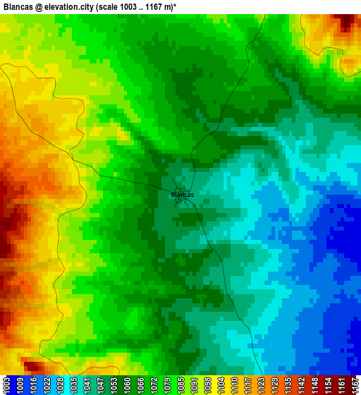
Below is the Elevation map of Blancas, which displays elevation range with different colors. Scale of the first map is from 1003 to 1167 m (3291 to 3829 ft) with average elevation of 1067.6 meters (=3503 ft) [note 1]
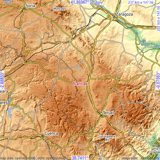
These maps also provides idea of topography and contour of this city, they are displayed at different zoom levels. More info about maps, scale and edge coordinates you can find below images.
| \ | Map #1 | Topo.Map |
| Scale [m] | 1003..1167 m | × |
| Scale [ft] | 3291..3829 ft | × |
| Average | 1067.6 m = 3503 ft | × |
| Width | 7.4 km = 4.6 mi | 236.7 km = 147.1 mi |
| Height | 7.4 km = 4.6 mi | 236.7 km = 147.1 mi |
| ↑Max Latitude | 40.847171° | 41.86967° |
| Latitude at center | 40.81392° | 40.81392° |
| ↓Min Latitude | 40.780652° | 39.7411° |
| ← Min Longitude | -1.526025° | -2.88833° |
| Longitude center | -1.48208° | -1.48208° |
| →Max Longitude | -1.438135° | -0.07583° |
Nearby cities:
Cities around Blancas sort by population:
• Monreal del Campo elevation 946 m
11 km,  105°
105°
• Caminreal 925 m
13.6 km,  78°
78°
• Fuentes Claras 913 m
14.5 km,  67°
67°
• Torrijo del Campo 927 m
12.2 km, 83°
• Ojos Negros 1148 m
8.6 km,  189°
189°
• Bello 1007 m
12.2 km,  353°
353°
• Odón 1091 m
10.6 km,  317°
317°
• Tornos 1024 m
16.9 km,  13°
13°
• Torralba de los Sisones 1042 m
8.8 km, 12°
• Setiles 1262 m
14.4 km,  232°
232°
• Pozuel del Campo 1117 m
5.1 km,  202°
202°
• Villar del Salz 1215 m
14.7 km, 185°
Multilingual:
 En español:
Blancas elevación 1050 m.
 En France:
Blancas élévation 1050 m.
 Auf Deutsch:
Blancas höhe über dem Meeresspiegel ist 1050 m.

Sources and notes:
- [note 1] Map square and city borders are not equal. Map elevation data is calculated only from area inside that square.
- [src 1] Elevation data from geonames database provided with same terms of usage.
- [src 2] The elevation map of Blancas is generated using elevation data from NASA's 3 arcsec (90m) resolution SRTM data.
- [src 3] Base (background) map © OpenStreetMap contributors tiles are generated by Geofabrik and OpenTopoMap.
Copyright & License:
This Blancas Elevation Map is licensed under CC BY-SA. You may reuse any part from this page, if you give a proper credit by linking to this URL:
 More info on terms of use page.