Rillo elevation
Rillo (Aragon, Provincia de Teruel), Spain elevation is 1273 meters and Rillo elevation in feet is 4177 ft above sea level [src 1]. Rillo is a seat of a third-order administrative division (feature code) with elevation that is 670 meters (2198 ft) bigger than average city elevation in Spain.
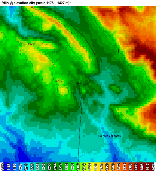
Below is the Elevation map of Rillo, which displays elevation range with different colors. Scale of the first map is from 1178 to 1427 m (3865 to 4682 ft) with average elevation of 1271.8 meters (=4173 ft) [note 1]
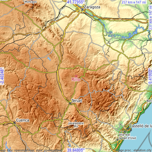
These maps also provides idea of topography and contour of this city, they are displayed at different zoom levels. More info about maps, scale and edge coordinates you can find below images.
| \ | Map #1 | Topo.Map |
| Scale [m] | 1178..1427 m | × |
| Scale [ft] | 3865..4682 ft | × |
| Average | 1271.8 m = 4173 ft | × |
| Width | 7.41 km = 4.6 mi | 237 km = 147.3 mi |
| Height | 7.41 km = 4.6 mi | 237 km = 147.3 mi |
| ↑Max Latitude | 40.755627° | 41.77955° |
| Latitude at center | 40.72233° | 40.72233° |
| ↓Min Latitude | 40.689016° | 39.64805° |
| ← Min Longitude | -1.040175° | -2.40248° |
| Longitude center | -0.99623° | -0.99623° |
| →Max Longitude | -0.952285° | 0.41002° |
Nearby cities:
Cities around Rillo sort by population:
• Perales del Alfambra elevation 1170 m
9.9 km,  182°
182°
• Argente 1249 m
14.5 km,  254°
254°
• Visiedo 1187 m
9.4 km,  244°
244°
• Orrios 1065 m
14.8 km, 176°
• Galve 1198 m
12.1 km,  127°
127°
• Fuentes Calientes 1252 m
3.5 km, 134°
• Pancrudo 1247 m
5.3 km,  327°
327°
• Cuevas de Almudén 1285 m
14.1 km,  94°
94°
• Mezquita de Jarque 1255 m
10.9 km, 90°
• Lidón 1219 m
9.8 km,  266°
266°
• Cañada Vellida 1314 m
7 km,  102°
102°
• Alpeñés 1225 m
10.4 km, 325°
Multilingual:
 En español:
Rillo elevación 1273 m.
 En France:
Rillo élévation 1273 m.


Sources and notes:
- [note 1] Map square and city borders are not equal. Map elevation data is calculated only from area inside that square.
- [src 1] Elevation data from geonames database provided with same terms of usage.
- [src 2] The elevation map of Rillo is generated using elevation data from NASA's 3 arcsec (90m) resolution SRTM data.
- [src 3] Base (background) map © OpenStreetMap contributors tiles are generated by Geofabrik and OpenTopoMap.
Copyright & License:
This Rillo Elevation Map is licensed under CC BY-SA. You may reuse any part from this page, if you give a proper credit by linking to this URL:
 More info on terms of use page.