Anglesola elevation
Anglesola (Catalonia, Província de Lleida), Spain elevation is 339 meters and Anglesola elevation in feet is 1112 ft above sea level [src 1]. Anglesola is a seat of a third-order administrative division (feature code) with elevation that is 264 meters (866 ft) smaller than average city elevation in Spain.
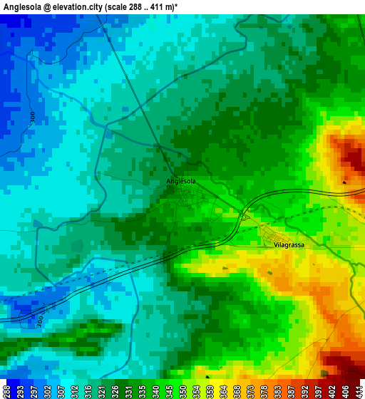
Below is the Elevation map of Anglesola, which displays elevation range with different colors. Scale of the first map is from 288 to 411 m (945 to 1348 ft) with average elevation of 327.8 meters (=1075 ft) [note 1]
These maps also provides idea of topography and contour of this city, they are displayed at different zoom levels. More info about maps, scale and edge coordinates you can find below images.
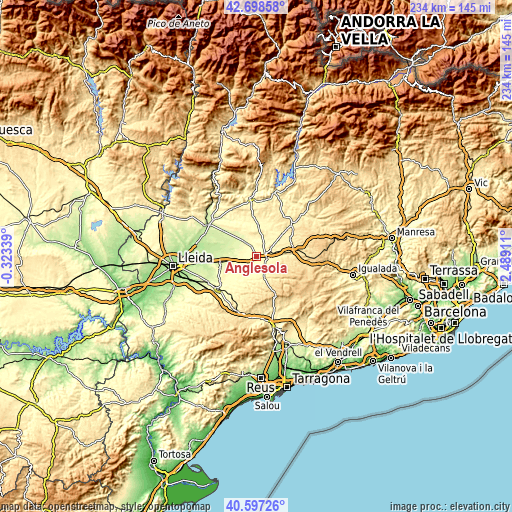
| \ | Map #1 | Topo.Map |
| Scale [m] | 288..411 m | × |
| Scale [ft] | 945..1348 ft | × |
| Average | 327.8 m = 1075 ft | × |
| Width | 7.3 km = 4.5 mi | 233.6 km = 145.2 mi |
| Height | 7.3 km = 4.5 mi | 233.6 km = 145.2 mi |
| ↑Max Latitude | 41.689315° | 42.69858° |
| Latitude at center | 41.65649° | 41.65649° |
| ↓Min Latitude | 41.623648° | 40.59726° |
| ← Min Longitude | 1.038915° | -0.32339° |
| Longitude center | 1.08286° | 1.08286° |
| →Max Longitude | 1.126805° | 2.48911° |
Nearby cities:
Cities around Anglesola sort by population:
• Tàrrega elevation 384 m
4.8 km,  102°
102°
• Bellpuig 308 m
6.8 km,  240°
240°
• La Fuliola 278 m
8.4 km,  319°
319°
• Vilanova de Bellpuig 297 m
10.9 km, 244°
• Castellserà 284 m
12.5 km,  326°
326°
• Verdú 439 m
7.1 km,  135°
135°
• Tornabous 297 m
5.5 km, 334°
• Castellnou de Seana 274 m
9.3 km,  264°
264°
• Ciutadilla 506 m
11.6 km,  156°
156°
• Ossó de Sió 392 m
12.6 km,  30°
30°
• Nalec 525 m
12.2 km,  166°
166°
• Ivars d'Urgell 257 m
8.4 km,  288°
288°
Multilingual:
 En español:
Anglesola elevación 339 m.
 En France:
Anglesola élévation 339 m.
 Auf Deutsch:
Anglesola höhe über dem Meeresspiegel ist 339 m.

Sources and notes:
- [note 1] Map square and city borders are not equal. Map elevation data is calculated only from area inside that square.
- [src 1] Elevation data from geonames database provided with same terms of usage.
- [src 2] The elevation map of Anglesola is generated using elevation data from NASA's 3 arcsec (90m) resolution SRTM data.
- [src 3] Base (background) map © OpenStreetMap contributors tiles are generated by Geofabrik and OpenTopoMap.
Copyright & License:
This Anglesola Elevation Map is licensed under CC BY-SA. You may reuse any part from this page, if you give a proper credit by linking to this URL:
 More info on terms of use page.