La Fuliola elevation
La Fuliola (Catalonia, Província de Lleida), Spain elevation is 278 meters and La Fuliola elevation in feet is 912 ft above sea level [src 1]. La Fuliola is a populated place (feature code) with elevation that is 325 meters (1066 ft) smaller than average city elevation in Spain.
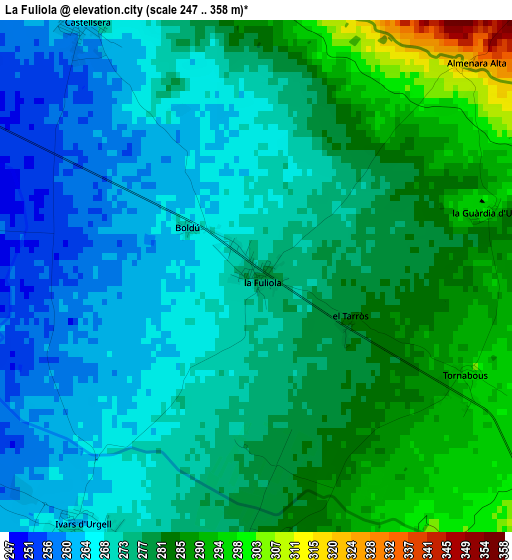
Below is the Elevation map of La Fuliola, which displays elevation range with different colors. Scale of the first map is from 247 to 358 m (810 to 1175 ft) with average elevation of 275.4 meters (=904 ft) [note 1]
These maps also provides idea of topography and contour of this city, they are displayed at different zoom levels. More info about maps, scale and edge coordinates you can find below images.
| \ | Map #1 | Topo.Map |
| Scale [m] | 247..358 m | × |
| Scale [ft] | 810..1175 ft | × |
| Average | 275.4 m = 904 ft | × |
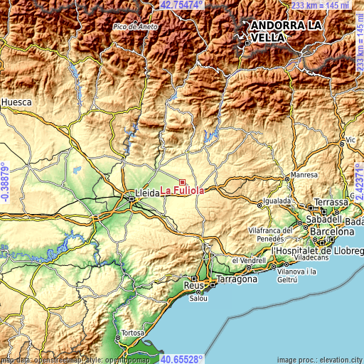
| Width | 7.29 km = 4.5 mi | 233.4 km = 145 mi |
| Height | 7.3 km = 4.5 mi | 233.4 km = 145 mi |
| ↑Max Latitude | 41.746376° | 42.75474° |
| Latitude at center | 41.71358° | 41.71358° |
| ↓Min Latitude | 41.680767° | 40.65528° |
| ← Min Longitude | 0.973515° | -0.38879° |
| Longitude center | 1.01746° | 1.01746° |
| →Max Longitude | 1.061405° | 2.42371° |
Nearby cities:
Cities around La Fuliola sort by population:
• Agramunt elevation 342 m
10.5 km,  38°
38°
• Bellpuig 308 m
9.8 km,  182°
182°
• Linyola 229 m
8.5 km,  259°
259°
• Golmés 278 m
11.4 km,  218°
218°
• Anglesola 339 m
8.4 km,  139°
139°
• Bellcaire d'Urgell 251 m
9.3 km,  295°
295°
• Vilanova de Bellpuig 297 m
11.9 km,  201°
201°
• Castellserà 284 m
4.3 km,  340°
340°
• Tornabous 297 m
3.3 km,  114°
114°
• Castellnou de Seana 274 m
8.3 km,  207°
207°
• Penelles 262 m
5.8 km,  313°
313°
• Ivars d'Urgell 257 m
4.5 km, 214°
Multilingual:
 En español:
Fuliola elevación 278 m.
 En France:
La Fuliola élévation 278 m.
 Auf Deutsch:
La Fuliola höhe über dem Meeresspiegel ist 278 m.

Sources and notes:
- [note 1] Map square and city borders are not equal. Map elevation data is calculated only from area inside that square.
- [src 1] Elevation data from geonames database provided with same terms of usage.
- [src 2] The elevation map of La Fuliola is generated using elevation data from NASA's 3 arcsec (90m) resolution SRTM data.
- [src 3] Base (background) map © OpenStreetMap contributors tiles are generated by Geofabrik and OpenTopoMap.
Copyright & License:
This La Fuliola Elevation Map is licensed under CC BY-SA. You may reuse any part from this page, if you give a proper credit by linking to this URL:
 More info on terms of use page.