Nalec elevation
Nalec (Catalonia, Província de Lleida), Spain elevation is 525 meters and Nalec elevation in feet is 1722 ft above sea level [src 1]. Nalec is a seat of a third-order administrative division (feature code) with elevation that is 78 meters (256 ft) smaller than average city elevation in Spain.
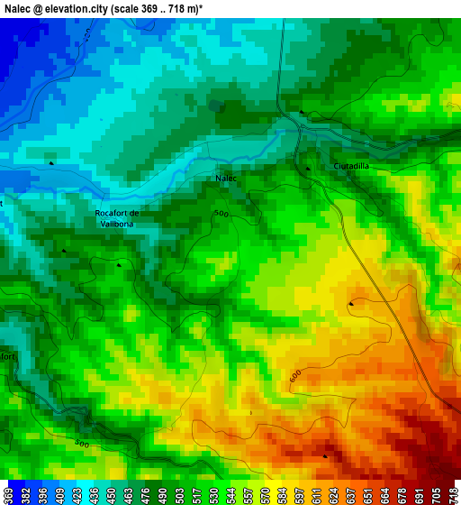
Below is the Elevation map of Nalec, which displays elevation range with different colors. Scale of the first map is from 369 to 718 m (1211 to 2356 ft) with average elevation of 515.1 meters (=1690 ft) [note 1]
These maps also provides idea of topography and contour of this city, they are displayed at different zoom levels. More info about maps, scale and edge coordinates you can find below images.
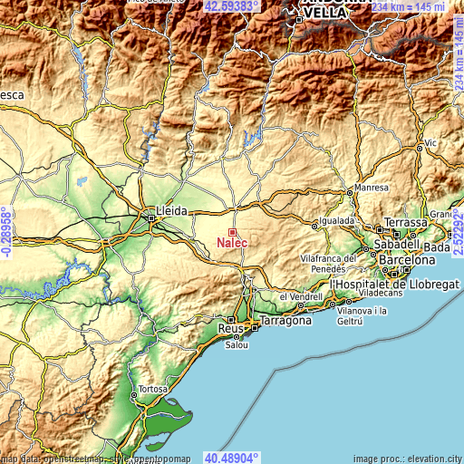
| \ | Map #1 | Topo.Map |
| Scale [m] | 369..718 m | × |
| Scale [ft] | 1211..2356 ft | × |
| Average | 515.1 m = 1690 ft | × |
| Width | 7.31 km = 4.5 mi | 234 km = 145.4 mi |
| Height | 7.31 km = 4.5 mi | 234 km = 145.4 mi |
| ↑Max Latitude | 41.582879° | 42.59383° |
| Latitude at center | 41.55° | 41.55° |
| ↓Min Latitude | 41.517104° | 40.48904° |
| ← Min Longitude | 1.072725° | -0.28958° |
| Longitude center | 1.11667° | 1.11667° |
| →Max Longitude | 1.160615° | 2.52292° |
Nearby cities:
Cities around Nalec sort by population:
• Tàrrega elevation 384 m
11 km,  10°
10°
• Bellpuig 308 m
12.2 km,  313°
313°
• Anglesola 339 m
12.2 km,  346°
346°
• Verdú 439 m
7.1 km,  17°
17°
• Guimerà 514 m
5.9 km,  74°
74°
• Ciutadilla 506 m
2.3 km,  56°
56°
• Fulleda 585 m
12.3 km,  218°
218°
• Blancafort 433 m
13 km,  163°
163°
• Forès 622 m
12.2 km,  127°
127°
• Vallfogona de Riucorb 585 m
10.1 km,  81°
81°
• Senan 625 m
9.3 km,  196°
196°
• Vallbona de les Monges 476 m
3.5 km, 221°
Multilingual:
 En español:
Nalech elevación 525 m.
 En France:
Nalec élévation 525 m.


Sources and notes:
- [note 1] Map square and city borders are not equal. Map elevation data is calculated only from area inside that square.
- [src 1] Elevation data from geonames database provided with same terms of usage.
- [src 2] The elevation map of Nalec is generated using elevation data from NASA's 3 arcsec (90m) resolution SRTM data.
- [src 3] Base (background) map © OpenStreetMap contributors tiles are generated by Geofabrik and OpenTopoMap.
Copyright & License:
This Nalec Elevation Map is licensed under CC BY-SA. You may reuse any part from this page, if you give a proper credit by linking to this URL:
 More info on terms of use page.