Senan elevation
Senan (Catalonia, Província de Tarragona), Spain elevation is 625 meters and Senan elevation in feet is 2051 ft above sea level [src 1]. Senan is a seat of a third-order administrative division (feature code) with elevation that is 22 meters (72 ft) bigger than average city elevation in Spain.
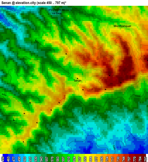
Below is the Elevation map of Senan, which displays elevation range with different colors. Scale of the first map is from 450 to 797 m (1476 to 2615 ft) with average elevation of 606.2 meters (=1989 ft) [note 1]
These maps also provides idea of topography and contour of this city, they are displayed at different zoom levels. More info about maps, scale and edge coordinates you can find below images.
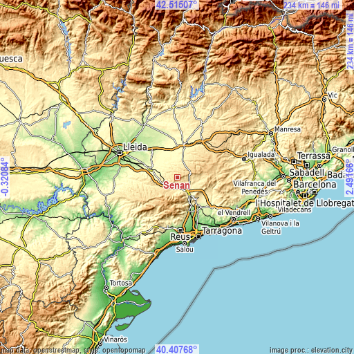
| \ | Map #1 | Topo.Map |
| Scale [m] | 450..797 m | × |
| Scale [ft] | 1476..2615 ft | × |
| Average | 606.2 m = 1989 ft | × |
| Width | 7.32 km = 4.5 mi | 234.3 km = 145.6 mi |
| Height | 7.32 km = 4.5 mi | 234.3 km = 145.6 mi |
| ↑Max Latitude | 41.50286° | 42.51507° |
| Latitude at center | 41.46994° | 41.46994° |
| ↓Min Latitude | 41.437003° | 40.40768° |
| ← Min Longitude | 1.041465° | -0.32084° |
| Longitude center | 1.08541° | 1.08541° |
| →Max Longitude | 1.129355° | 2.49166° |
Nearby cities:
Cities around Senan sort by population:
• Montblanc elevation 350 m
12.2 km,  148°
148°
• Arbeca 340 m
15.6 km,  300°
300°
• Vimbodí 489 m
8.2 km,  200°
200°
• Vinaixa 474 m
9.4 km,  244°
244°
• Guimerà 514 m
13.4 km,  38°
38°
• Ciutadilla 506 m
11.1 km,  23°
23°
• Vallclara 628 m
13.2 km,  220°
220°
• Fulleda 585 m
5.2 km,  261°
261°
• Forès 622 m
12.4 km,  83°
83°
• Nalec 525 m
9.3 km, 16°
• Blancafort 433 m
7.2 km,  120°
120°
• Vallbona de les Monges 476 m
6.3 km,  2°
2°
Multilingual:
 En español:
Senant elevación 625 m.
 En France:
Senan élévation 625 m.


Sources and notes:
- [note 1] Map square and city borders are not equal. Map elevation data is calculated only from area inside that square.
- [src 1] Elevation data from geonames database provided with same terms of usage.
- [src 2] The elevation map of Senan is generated using elevation data from NASA's 3 arcsec (90m) resolution SRTM data.
- [src 3] Base (background) map © OpenStreetMap contributors tiles are generated by Geofabrik and OpenTopoMap.
Copyright & License:
This Senan Elevation Map is licensed under CC BY-SA. You may reuse any part from this page, if you give a proper credit by linking to this URL:
 More info on terms of use page.