Vinaixa elevation
Vinaixa (Catalonia, Província de Lleida), Spain elevation is 474 meters and Vinaixa elevation in feet is 1555 ft above sea level [src 1]. Vinaixa is a seat of a third-order administrative division (feature code) with elevation that is 129 meters (423 ft) smaller than average city elevation in Spain.
Below is the Elevation map of Vinaixa, which displays elevation range with different colors. Scale of the first map is from 407 to 656 m (1335 to 2152 ft) with average elevation of 539.4 meters (=1770 ft) [note 1]
These maps also provides idea of topography and contour of this city, they are displayed at different zoom levels. More info about maps, scale and edge coordinates you can find below images.
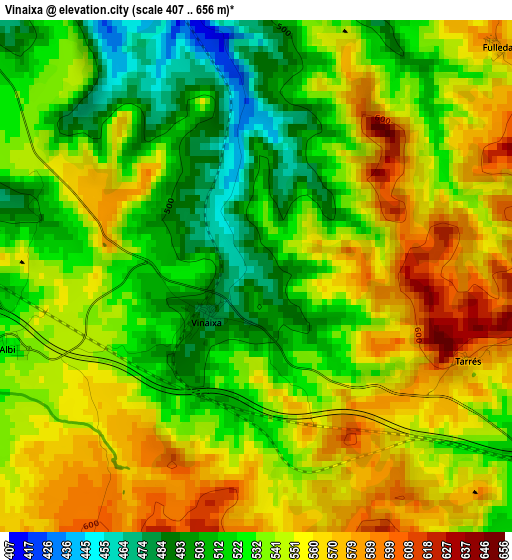
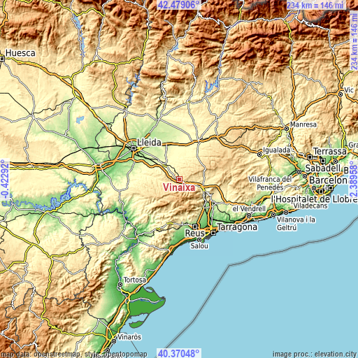
| \ | Map #1 | Topo.Map |
| Scale [m] | 407..656 m | × |
| Scale [ft] | 1335..2152 ft | × |
| Average | 539.4 m = 1770 ft | × |
| Width | 7.33 km = 4.6 mi | 234.5 km = 145.7 mi |
| Height | 7.33 km = 4.6 mi | 234.4 km = 145.6 mi |
| ↑Max Latitude | 41.466269° | 42.47906° |
| Latitude at center | 41.43333° | 41.43333° |
| ↓Min Latitude | 41.400375° | 40.37048° |
| ← Min Longitude | 0.939385° | -0.42292° |
| Longitude center | 0.98333° | 0.98333° |
| →Max Longitude | 1.027275° | 2.38958° |
Nearby cities:
Cities around Vinaixa sort by population:
• Montblanc elevation 350 m
16.2 km,  113°
113°
• Arbeca 340 m
13 km,  337°
337°
• Vimbodí 489 m
6.7 km,  122°
122°
• Ulldemolins 649 m
15.2 km,  215°
215°
• Vilanova de Prades 905 m
9.7 km,  193°
193°
• Vallclara 628 m
6 km,  179°
179°
• Fulleda 585 m
4.8 km,  45°
45°
• Capafonts 696 m
15.4 km,  164°
164°
• Blancafort 433 m
14.7 km,  88°
88°
• Prades 953 m
13.7 km, 178°
• Vallbona de les Monges 476 m
13.6 km,  40°
40°
• Senan 625 m
9.4 km,  64°
64°
Multilingual:
 En español:
Vinaixa elevación 474 m.
 En France:
Vinaixa élévation 474 m.


Sources and notes:
- [note 1] Map square and city borders are not equal. Map elevation data is calculated only from area inside that square.
- [src 1] Elevation data from geonames database provided with same terms of usage.
- [src 2] The elevation map of Vinaixa is generated using elevation data from NASA's 3 arcsec (90m) resolution SRTM data.
- [src 3] Base (background) map © OpenStreetMap contributors tiles are generated by Geofabrik and OpenTopoMap.
Copyright & License:
This Vinaixa Elevation Map is licensed under CC BY-SA. You may reuse any part from this page, if you give a proper credit by linking to this URL:
 More info on terms of use page.