Capafonts elevation
Capafonts (Catalonia, Província de Tarragona), Spain elevation is 696 meters and Capafonts elevation in feet is 2283 ft above sea level [src 1]. Capafonts is a seat of a third-order administrative division (feature code) with elevation that is 93 meters (305 ft) bigger than average city elevation in Spain.
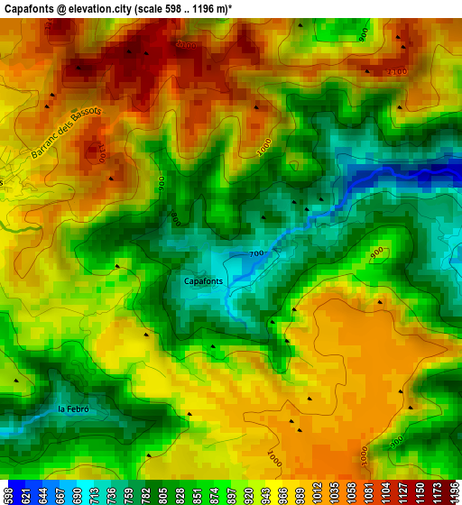
Below is the Elevation map of Capafonts, which displays elevation range with different colors. Scale of the first map is from 598 to 1196 m (1962 to 3924 ft) with average elevation of 916.1 meters (=3006 ft) [note 1]
These maps also provides idea of topography and contour of this city, they are displayed at different zoom levels. More info about maps, scale and edge coordinates you can find below images.
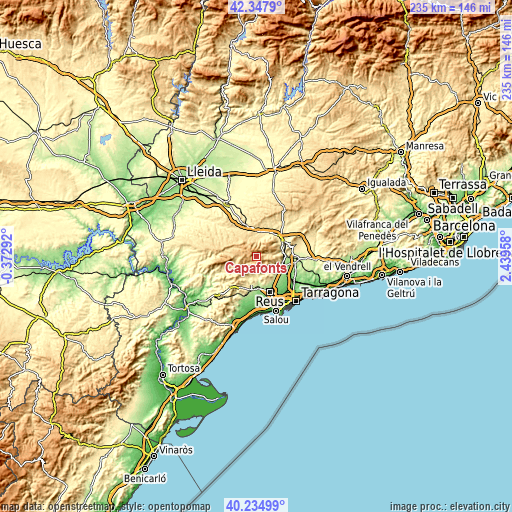
| \ | Map #1 | Topo.Map |
| Scale [m] | 598..1196 m | × |
| Scale [ft] | 1962..3924 ft | × |
| Average | 916.1 m = 3006 ft | × |
| Width | 7.34 km = 4.6 mi | 234.9 km = 146 mi |
| Height | 7.34 km = 4.6 mi | 234.9 km = 146 mi |
| ↑Max Latitude | 41.333006° | 42.3479° |
| Latitude at center | 41.3° | 41.3° |
| ↓Min Latitude | 41.266977° | 40.23499° |
| ← Min Longitude | 0.989385° | -0.37292° |
| Longitude center | 1.03333° | 1.03333° |
| →Max Longitude | 1.077275° | 2.43958° |
Nearby cities:
Cities around Capafonts sort by population:
• Montblanc elevation 350 m
13.7 km,  51°
51°
• La Selva del Camp 241 m
12.9 km,  137°
137°
• Alcover 246 m
12.2 km,  109°
109°
• Alforja 373 m
11 km,  206°
206°
• Almoster 282 m
13.1 km,  150°
150°
• Vimbodí 489 m
11.3 km,  7°
7°
• Vilaplana 371 m
8 km,  180°
180°
• Ulldemolins 649 m
13.3 km,  280°
280°
• Vilanova de Prades 905 m
8.4 km,  310°
310°
• Vallclara 628 m
9.8 km,  334°
334°
• Mont-ral 787 m
5.9 km, 108°
• Prades 953 m
3.9 km,  286°
286°
Multilingual:
 En español:
Capafons elevación 696 m.
 En France:
Capafonts élévation 696 m.
 Auf Deutsch:
Capafonts höhe über dem Meeresspiegel ist 696 m.

Sources and notes:
- [note 1] Map square and city borders are not equal. Map elevation data is calculated only from area inside that square.
- [src 1] Elevation data from geonames database provided with same terms of usage.
- [src 2] The elevation map of Capafonts is generated using elevation data from NASA's 3 arcsec (90m) resolution SRTM data.
- [src 3] Base (background) map © OpenStreetMap contributors tiles are generated by Geofabrik and OpenTopoMap.
Copyright & License:
This Capafonts Elevation Map is licensed under CC BY-SA. You may reuse any part from this page, if you give a proper credit by linking to this URL:
 More info on terms of use page.