Araia elevation
Araia (Basque Country, Araba / Álava), Spain elevation is 609 meters and Araia elevation in feet is 1998 ft above sea level [src 1]. Araia is a populated place (feature code) with elevation that is 6 meters (20 ft) bigger than average city elevation in Spain.
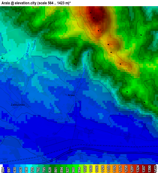
Below is the Elevation map of Araia, which displays elevation range with different colors. Scale of the first map is from 564 to 1423 m (1850 to 4669 ft) with average elevation of 751.8 meters (=2467 ft) [note 1]
These maps also provides idea of topography and contour of this city, they are displayed at different zoom levels. More info about maps, scale and edge coordinates you can find below images.
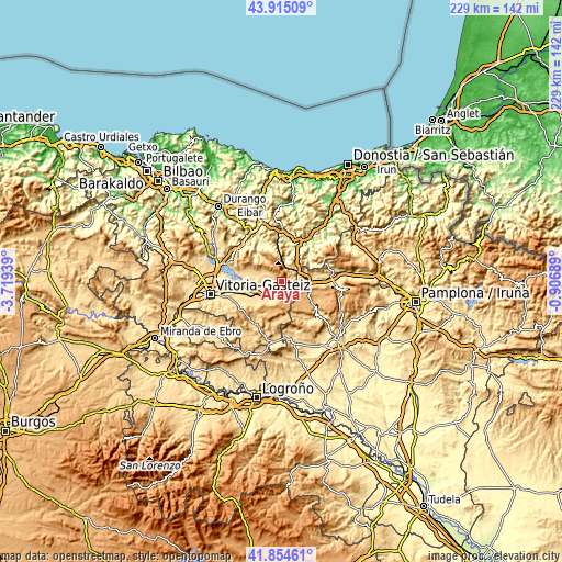
| \ | Map #1 | Topo.Map |
| Scale [m] | 564..1423 m | × |
| Scale [ft] | 1850..4669 ft | × |
| Average | 751.8 m = 2467 ft | × |
| Width | 7.16 km = 4.4 mi | 229.1 km = 142.4 mi |
| Height | 7.16 km = 4.4 mi | 229.1 km = 142.4 mi |
| ↑Max Latitude | 42.925637° | 43.91509° |
| Latitude at center | 42.89345° | 42.89345° |
| ↓Min Latitude | 42.861246° | 41.85461° |
| ← Min Longitude | -2.357085° | -3.71939° |
| Longitude center | -2.31314° | -2.31314° |
| →Max Longitude | -2.269195° | -0.90689° |
Nearby cities:
Cities around Araia sort by population:
• Altsasu elevation 517 m
12.1 km,  86°
86°
• Agurain / Salvatierra 593 m
7.9 km,  233°
233°
• Idiazabal 218 m
14.7 km,  26°
26°
• Olazagutía 545 m
9.8 km,  101°
101°
• Segura 253 m
13.6 km,  20°
20°
• Eulate 732 m
15.7 km,  146°
146°
• Mutiloa 240 m
14.8 km,  12°
12°
• Larraona 778 m
13.5 km,  160°
160°
• Aranarache 794 m
14.4 km, 151°
• Zerain 326 m
13.6 km, 13°
• Zegama 301 m
9.3 km, 11°
• Ziordia 555 m
7.3 km,  110°
110°
Multilingual:
 En español:
Araia elevación 609 m.
 En France:
Araia élévation 609 m.


Sources and notes:
- [note 1] Map square and city borders are not equal. Map elevation data is calculated only from area inside that square.
- [src 1] Elevation data from geonames database provided with same terms of usage.
- [src 2] The elevation map of Araia is generated using elevation data from NASA's 3 arcsec (90m) resolution SRTM data.
- [src 3] Base (background) map © OpenStreetMap contributors tiles are generated by Geofabrik and OpenTopoMap.
Copyright & License:
This Araia Elevation Map is licensed under CC BY-SA. You may reuse any part from this page, if you give a proper credit by linking to this URL:
 More info on terms of use page.