Larraona elevation
Larraona (Navarre, Provincia de Navarra), Spain elevation is 778 meters and Larraona elevation in feet is 2552 ft above sea level [src 1]. Larraona is a seat of a third-order administrative division (feature code) with elevation that is 175 meters (574 ft) bigger than average city elevation in Spain.
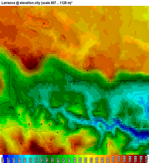
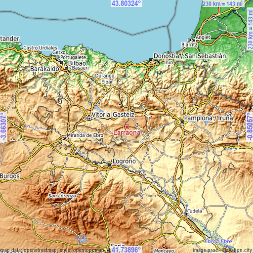
Below is the Elevation map of Larraona, which displays elevation range with different colors. Scale of the first map is from 607 to 1128 m (1991 to 3701 ft) with average elevation of 888.9 meters (=2916 ft) [note 1]
These maps also provides idea of topography and contour of this city, they are displayed at different zoom levels. More info about maps, scale and edge coordinates you can find below images.
| \ | Map #1 | Topo.Map |
| Scale [m] | 607..1128 m | × |
| Scale [ft] | 1991..3701 ft | × |
| Average | 888.9 m = 2916 ft | × |
| Width | 7.17 km = 4.5 mi | 229.5 km = 142.6 mi |
| Height | 7.17 km = 4.5 mi | 229.5 km = 142.6 mi |
| ↑Max Latitude | 42.811946° | 43.80324° |
| Latitude at center | 42.7797° | 42.7797° |
| ↓Min Latitude | 42.747437° | 41.73896° |
| ← Min Longitude | -2.300765° | -3.66307° |
| Longitude center | -2.25682° | -2.25682° |
| →Max Longitude | -2.212875° | -0.85057° |
Nearby cities:
Cities around Larraona sort by population:
• Altsasu elevation 517 m
15.3 km,  29°
29°
• Agurain / Salvatierra 593 m
13.6 km,  306°
306°
• Olazagutía 545 m
11.8 km, 25°
• Araia 609 m
13.5 km,  340°
340°
• Ancín 486 m
14.4 km,  157°
157°
• Eulate 732 m
4.1 km,  95°
95°
• Metauten 527 m
15.4 km,  137°
137°
• Zúñiga 568 m
10.3 km,  199°
199°
• Legaria 480 m
16 km,  154°
154°
• Aranarache 794 m
2.3 km,  89°
89°
• Nazar 744 m
16 km,  186°
186°
• Ziordia 555 m
10.4 km,  12°
12°
Multilingual:
 En español:
Larraona elevación 778 m.
 En France:
Larraona élévation 778 m.
 Auf Deutsch:
Larraona höhe über dem Meeresspiegel ist 778 m.

Sources and notes:
- [note 1] Map square and city borders are not equal. Map elevation data is calculated only from area inside that square.
- [src 1] Elevation data from geonames database provided with same terms of usage.
- [src 2] The elevation map of Larraona is generated using elevation data from NASA's 3 arcsec (90m) resolution SRTM data.
- [src 3] Base (background) map © OpenStreetMap contributors tiles are generated by Geofabrik and OpenTopoMap.
Copyright & License:
This Larraona Elevation Map is licensed under CC BY-SA. You may reuse any part from this page, if you give a proper credit by linking to this URL:
 More info on terms of use page.