Idiazabal elevation
Idiazabal (Basque Country, Gipuzkoa), Spain elevation is 218 meters and Idiazabal elevation in feet is 715 ft above sea level [src 1]. Idiazabal is a seat of a third-order administrative division (feature code) with elevation that is 385 meters (1263 ft) smaller than average city elevation in Spain.
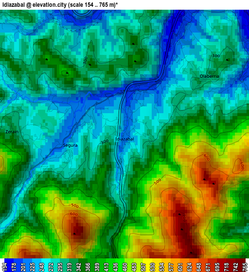
Below is the Elevation map of Idiazabal, which displays elevation range with different colors. Scale of the first map is from 154 to 765 m (505 to 2510 ft) with average elevation of 359.5 meters (=1179 ft) [note 1]
These maps also provides idea of topography and contour of this city, they are displayed at different zoom levels. More info about maps, scale and edge coordinates you can find below images.
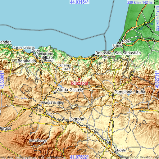
| \ | Map #1 | Topo.Map |
| Scale [m] | 154..765 m | × |
| Scale [ft] | 505..2510 ft | × |
| Average | 359.5 m = 1179 ft | × |
| Width | 7.15 km = 4.4 mi | 228.7 km = 142.1 mi |
| Height | 7.15 km = 4.4 mi | 228.7 km = 142.1 mi |
| ↑Max Latitude | 43.044015° | 44.03154° |
| Latitude at center | 43.01189° | 43.01189° |
| ↓Min Latitude | 42.979748° | 41.97502° |
| ← Min Longitude | -2.277505° | -3.63981° |
| Longitude center | -2.23356° | -2.23356° |
| →Max Longitude | -2.189615° | -0.82731° |
Nearby cities:
Cities around Idiazabal sort by population:
• Beasain elevation 236 m
5 km,  31°
31°
• Ataun 202 m
4.7 km,  97°
97°
• Segura 253 m
1.7 km,  253°
253°
• Olaberria 325 m
3 km,  55°
55°
• Mutiloa 240 m
3.4 km,  291°
291°
• Zaldibia 172 m
7.3 km,  67°
67°
• Ordizia 145 m
6.6 km,  44°
44°
• Zegama 301 m
6.2 km,  229°
229°
• Gabiria 401 m
5.6 km,  318°
318°
• Lazkao 170 m
4.5 km, 59°
• Ormaiztegi 203 m
4 km,  331°
331°
• Zerain 326 m
3.2 km,  270°
270°
Multilingual:
 En español:
Idiazábal elevación 218 m.
 En France:
Idiazabal élévation 218 m.
 Auf Deutsch:
Idiazabal höhe über dem Meeresspiegel ist 218 m.

Sources and notes:
- [note 1] Map square and city borders are not equal. Map elevation data is calculated only from area inside that square.
- [src 1] Elevation data from geonames database provided with same terms of usage.
- [src 2] The elevation map of Idiazabal is generated using elevation data from NASA's 3 arcsec (90m) resolution SRTM data.
- [src 3] Base (background) map © OpenStreetMap contributors tiles are generated by Geofabrik and OpenTopoMap.
Copyright & License:
This Idiazabal Elevation Map is licensed under CC BY-SA. You may reuse any part from this page, if you give a proper credit by linking to this URL:
 More info on terms of use page.