Arganza elevation
Arganza (Castille and León, Provincia de León), Spain elevation is 596 meters and Arganza elevation in feet is 1955 ft above sea level [src 1]. Arganza is a seat of a third-order administrative division (feature code) with elevation that is 7 meters (23 ft) smaller than average city elevation in Spain.
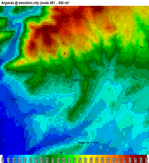
Below is the Elevation map of Arganza, which displays elevation range with different colors. Scale of the first map is from 481 to 942 m (1578 to 3091 ft) with average elevation of 630.6 meters (=2069 ft) [note 1]
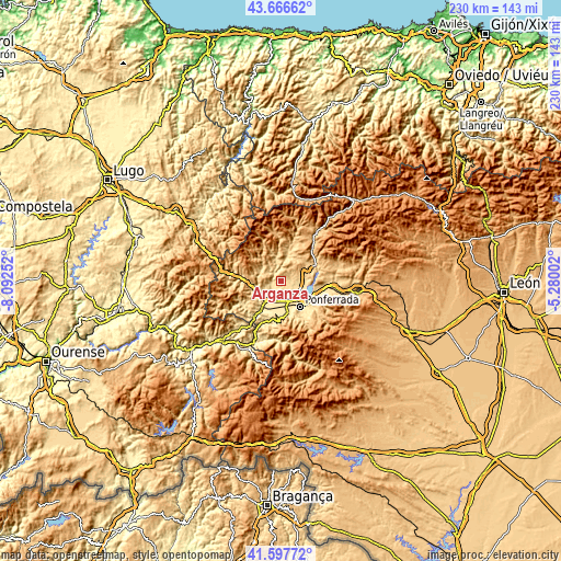
These maps also provides idea of topography and contour of this city, they are displayed at different zoom levels. More info about maps, scale and edge coordinates you can find below images.
| \ | Map #1 | Topo.Map |
| Scale [m] | 481..942 m | × |
| Scale [ft] | 1578..3091 ft | × |
| Average | 630.6 m = 2069 ft | × |
| Width | 7.19 km = 4.5 mi | 230 km = 142.9 mi |
| Height | 7.19 km = 4.5 mi | 230 km = 142.9 mi |
| ↑Max Latitude | 42.673088° | 43.66662° |
| Latitude at center | 42.64077° | 42.64077° |
| ↓Min Latitude | 42.608435° | 41.59772° |
| ← Min Longitude | -6.730215° | -8.09252° |
| Longitude center | -6.68627° | -6.68627° |
| →Max Longitude | -6.642325° | -5.28002° |
Nearby cities:
Cities around Arganza sort by population:
• Ponferrada elevation 519 m
12.8 km,  144°
144°
• Cacabelos 486 m
5.5 km,  214°
214°
• Villafranca del Bierzo 506 m
10.9 km,  249°
249°
• Camponaraya 492 m
7.2 km,  167°
167°
• Carracedelo 456 m
10.2 km,  202°
202°
• Vega de Espinareda 616 m
9.8 km,  15°
15°
• Villadecanes 525 m
9.1 km,  221°
221°
• Congosto 689 m
13.8 km,  100°
100°
• Cubillos del Sil 586 m
10.2 km, 99°
• Corullón 523 m
12.9 km,  237°
237°
• Berlanga del Bierzo 805 m
12 km,  33°
33°
• Sancedo 675 m
5.1 km,  55°
55°
Multilingual:
 En español:
Arganza elevación 596 m.
 En France:
Arganza élévation 596 m.


Sources and notes:
- [note 1] Map square and city borders are not equal. Map elevation data is calculated only from area inside that square.
- [src 1] Elevation data from geonames database provided with same terms of usage.
- [src 2] The elevation map of Arganza is generated using elevation data from NASA's 3 arcsec (90m) resolution SRTM data.
- [src 3] Base (background) map © OpenStreetMap contributors tiles are generated by Geofabrik and OpenTopoMap.
Copyright & License:
This Arganza Elevation Map is licensed under CC BY-SA. You may reuse any part from this page, if you give a proper credit by linking to this URL:
 More info on terms of use page.