Congosto elevation
Congosto (Castille and León, Provincia de León), Spain elevation is 689 meters and Congosto elevation in feet is 2260 ft above sea level [src 1]. Congosto is a seat of a third-order administrative division (feature code) with elevation that is 86 meters (282 ft) bigger than average city elevation in Spain.
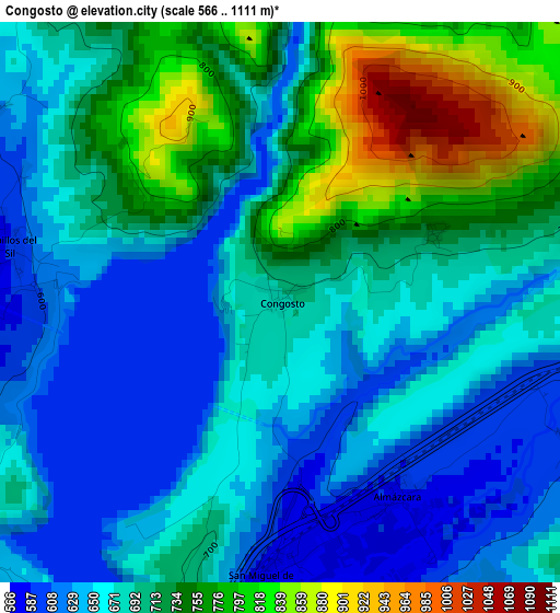
Below is the Elevation map of Congosto, which displays elevation range with different colors. Scale of the first map is from 566 to 1111 m (1857 to 3645 ft) with average elevation of 694 meters (=2277 ft) [note 1]
These maps also provides idea of topography and contour of this city, they are displayed at different zoom levels. More info about maps, scale and edge coordinates you can find below images.
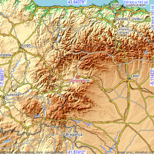
| \ | Map #1 | Topo.Map |
| Scale [m] | 566..1111 m | × |
| Scale [ft] | 1857..3645 ft | × |
| Average | 694 m = 2277 ft | × |
| Width | 7.19 km = 4.5 mi | 230.1 km = 143 mi |
| Height | 7.19 km = 4.5 mi | 230.1 km = 143 mi |
| ↑Max Latitude | 42.649881° | 43.64379° |
| Latitude at center | 42.61755° | 42.61755° |
| ↓Min Latitude | 42.585203° | 41.57412° |
| ← Min Longitude | -6.564425° | -7.92673° |
| Longitude center | -6.52048° | -6.52048° |
| →Max Longitude | -6.476535° | -5.11423° |
Nearby cities:
Cities around Congosto sort by population:
• Ponferrada elevation 519 m
10 km,  218°
218°
• Bembibre 648 m
8.6 km,  89°
89°
• Toreno 683 m
9.1 km,  4°
4°
• Camponaraya 492 m
12.8 km,  249°
249°
• Vega de Espinareda 616 m
16.2 km,  317°
317°
• Torre del Bierzo 700 m
12.6 km, 94°
• Castropodame 746 m
6 km,  134°
134°
• Cubillos del Sil 586 m
3.6 km,  283°
283°
• Arganza 596 m
13.8 km, 280°
• Molinaseca 582 m
8.8 km,  179°
179°
• Berlanga del Bierzo 805 m
14.4 km,  331°
331°
• Sancedo 675 m
10.8 km,  300°
300°
Multilingual:
 En español:
Congosto elevación 689 m.
 En France:
Congosto élévation 689 m.
 Auf Deutsch:
Congosto höhe über dem Meeresspiegel ist 689 m.

Sources and notes:
- [note 1] Map square and city borders are not equal. Map elevation data is calculated only from area inside that square.
- [src 1] Elevation data from geonames database provided with same terms of usage.
- [src 2] The elevation map of Congosto is generated using elevation data from NASA's 3 arcsec (90m) resolution SRTM data.
- [src 3] Base (background) map © OpenStreetMap contributors tiles are generated by Geofabrik and OpenTopoMap.
Copyright & License:
This Congosto Elevation Map is licensed under CC BY-SA. You may reuse any part from this page, if you give a proper credit by linking to this URL:
 More info on terms of use page.