Cacabelos elevation
Cacabelos (Castille and León, Provincia de León), Spain elevation is 486 meters and Cacabelos elevation in feet is 1594 ft above sea level [src 1]. Cacabelos is a seat of a third-order administrative division (feature code) with elevation that is 117 meters (384 ft) smaller than average city elevation in Spain.
Below is the Elevation map of Cacabelos, which displays elevation range with different colors. Scale of the first map is from 449 to 763 m (1473 to 2503 ft) with average elevation of 515.1 meters (=1690 ft) [note 1]
These maps also provides idea of topography and contour of this city, they are displayed at different zoom levels. More info about maps, scale and edge coordinates you can find below images.
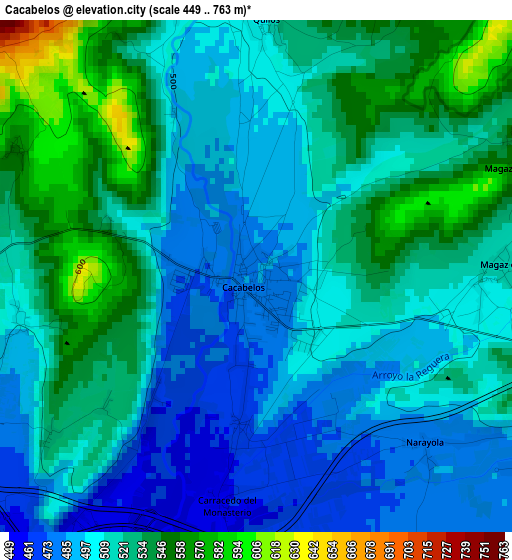
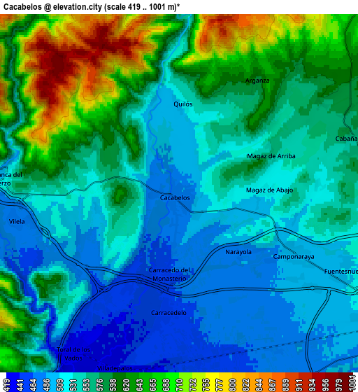
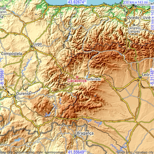
| \ | Map #1 | Map #2 | Topo.Map |
| Scale [m] | 449..763 m | 419..1001 m | × |
| Scale [ft] | 1473..2503 ft | 1375..3284 ft | × |
| Average | 515.1 m = 1690 ft | 568.8 m = 1866 ft | × |
| Width | 7.19 km = 4.5 mi | 14.39 km = 8.9 mi | 230.2 km = 143 mi |
| Height | 7.19 km = 4.5 mi | 14.39 km = 8.9 mi | 230.2 km = 143 mi |
| ↑Max Latitude | 42.63255° | 42.664872° | 43.62674° |
| Latitude at center | 42.60021° | 42.60021° | 42.60021° |
| ↓Min Latitude | 42.567854° | 42.535481° | 41.55649° |
| ← Min Longitude | -6.767675° | -6.811621° | -8.12998° |
| Longitude center | -6.72373° | -6.72373° | -6.72373° |
| →Max Longitude | -6.679785° | -6.635839° | -5.31748° |
Nearby cities:
Cities around Cacabelos sort by population:
• Ponferrada elevation 519 m
12 km,  119°
119°
• Villafranca del Bierzo 506 m
7.1 km,  275°
275°
• Camponaraya 492 m
5.3 km, 118°
• Carracedelo 456 m
5 km,  188°
188°
• Villadecanes 525 m
3.7 km,  232°
232°
• Cubillos del Sil 586 m
13.4 km,  78°
78°
• Corullón 523 m
8.2 km,  253°
253°
• Arganza 596 m
5.5 km,  34°
34°
• Priaranza del Bierzo 511 m
11 km,  156°
156°
• Carucedo 508 m
12.7 km,  195°
195°
• Borrenes 556 m
12.2 km,  179°
179°
• Sancedo 675 m
10.4 km,  44°
44°
Multilingual:
 En español:
Cacabelos elevación 486 m.
 En France:
Cacabelos élévation 486 m.
 Auf Deutsch:
Cacabelos höhe über dem Meeresspiegel ist 486 m.

Sources and notes:
- [note 1] Map square and city borders are not equal. Map elevation data is calculated only from area inside that square.
- [src 1] Elevation data from geonames database provided with same terms of usage.
- [src 2] The elevation map of Cacabelos is generated using elevation data from NASA's 3 arcsec (90m) resolution SRTM data.
- [src 3] Base (background) map © OpenStreetMap contributors tiles are generated by Geofabrik and OpenTopoMap.
Copyright & License:
This Cacabelos Elevation Map is licensed under CC BY-SA. You may reuse any part from this page, if you give a proper credit by linking to this URL:
 More info on terms of use page.