Bañobárez elevation
Bañobárez (Castille and León, Provincia de Salamanca), Spain elevation is 750 meters and Bañobárez elevation in feet is 2461 ft above sea level [src 1]. Bañobárez is a seat of a third-order administrative division (feature code) with elevation that is 147 meters (482 ft) bigger than average city elevation in Spain.
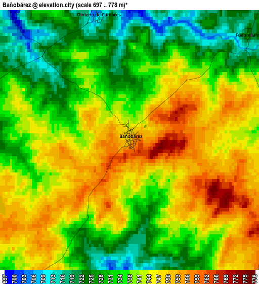
Below is the Elevation map of Bañobárez, which displays elevation range with different colors. Scale of the first map is from 697 to 778 m (2287 to 2552 ft) with average elevation of 738.6 meters (=2423 ft) [note 1]
These maps also provides idea of topography and contour of this city, they are displayed at different zoom levels. More info about maps, scale and edge coordinates you can find below images.
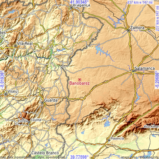
| \ | Map #1 | Topo.Map |
| Scale [m] | 697..778 m | × |
| Scale [ft] | 2287..2552 ft | × |
| Average | 738.6 m = 2423 ft | × |
| Width | 7.39 km = 4.6 mi | 236.6 km = 147 mi |
| Height | 7.39 km = 4.6 mi | 236.5 km = 147 mi |
| ↑Max Latitude | 40.881484° | 41.90345° |
| Latitude at center | 40.84825° | 40.84825° |
| ↓Min Latitude | 40.814999° | 39.77598° |
| ← Min Longitude | -6.657055° | -8.01936° |
| Longitude center | -6.61311° | -6.61311° |
| →Max Longitude | -6.569165° | -5.20686° |
Nearby cities:
Cities around Bañobárez sort by population:
• Lumbrales elevation 675 m
13.2 km,  317°
317°
• Villavieja de Yeltes 743 m
12.6 km,  75°
75°
• San Felices de los Gallegos 668 m
8 km,  271°
271°
• Villar de Ciervo 686 m
16.2 km,  220°
220°
• Yecla de Yeltes 721 m
16.1 km,  40°
40°
• Villar de la Yegua 708 m
15.6 km,  209°
209°
• Cerralbo 676 m
14.1 km,  8°
8°
• Bogajo 715 m
9.5 km,  46°
46°
• Ahigal de los Aceiteros 641 m
11.6 km,  283°
283°
• Olmedo de Camaces 710 m
3.6 km,  345°
345°
• Puerto Seguro 637 m
12.7 km,  259°
259°
• La Bouza 614 m
15.4 km, 265°
Multilingual:
 En español:
Bañobárez elevación 750 m.
 En France:
Bañobárez élévation 750 m.
 Auf Deutsch:
Bañobárez höhe über dem Meeresspiegel ist 750 m.

Sources and notes:
- [note 1] Map square and city borders are not equal. Map elevation data is calculated only from area inside that square.
- [src 1] Elevation data from geonames database provided with same terms of usage.
- [src 2] The elevation map of Bañobárez is generated using elevation data from NASA's 3 arcsec (90m) resolution SRTM data.
- [src 3] Base (background) map © OpenStreetMap contributors tiles are generated by Geofabrik and OpenTopoMap.
Copyright & License:
This Bañobárez Elevation Map is licensed under CC BY-SA. You may reuse any part from this page, if you give a proper credit by linking to this URL:
 More info on terms of use page.