Cerralbo elevation
Cerralbo (Castille and León, Provincia de Salamanca), Spain elevation is 676 meters and Cerralbo elevation in feet is 2218 ft above sea level [src 1]. Cerralbo is a seat of a third-order administrative division (feature code) with elevation that is 73 meters (240 ft) bigger than average city elevation in Spain.
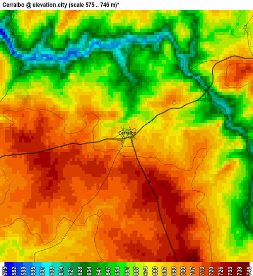
Below is the Elevation map of Cerralbo, which displays elevation range with different colors. Scale of the first map is from 575 to 746 m (1886 to 2448 ft) with average elevation of 681.6 meters (=2236 ft) [note 1]
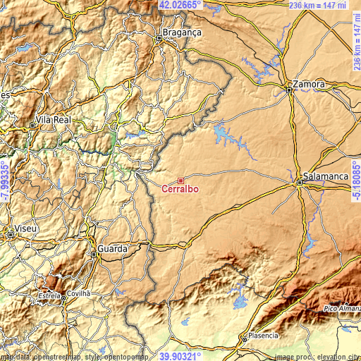
These maps also provides idea of topography and contour of this city, they are displayed at different zoom levels. More info about maps, scale and edge coordinates you can find below images.
| \ | Map #1 | Topo.Map |
| Scale [m] | 575..746 m | × |
| Scale [ft] | 1886..2448 ft | × |
| Average | 681.6 m = 2236 ft | × |
| Width | 7.38 km = 4.6 mi | 236.1 km = 146.7 mi |
| Height | 7.38 km = 4.6 mi | 236.1 km = 146.7 mi |
| ↑Max Latitude | 41.006641° | 42.02665° |
| Latitude at center | 40.97347° | 40.97347° |
| ↓Min Latitude | 40.940282° | 39.90321° |
| ← Min Longitude | -6.631045° | -7.99335° |
| Longitude center | -6.5871° | -6.5871° |
| →Max Longitude | -6.543155° | -5.18085° |
Nearby cities:
Cities around Cerralbo sort by population:
• Lumbrales elevation 675 m
11.9 km,  248°
248°
• Barruecopardo 710 m
12.7 km,  329°
329°
• Yecla de Yeltes 721 m
8.4 km,  100°
100°
• Villasbuenas 734 m
9.9 km,  355°
355°
• Encinasola de los Comendadores 711 m
7.9 km,  35°
35°
• Bogajo 715 m
8.8 km,  147°
147°
• Guadramiro 749 m
9.2 km,  58°
58°
• Bermellar 642 m
7.5 km,  292°
292°
• Valderrodrigo 734 m
12.1 km,  32°
32°
• Saldeana 664 m
6.9 km,  319°
319°
• Olmedo de Camaces 710 m
10.9 km,  196°
196°
• Moronta 758 m
13.1 km,  88°
88°
Multilingual:
 En español:
Cerralbo elevación 676 m.
 En France:
Cerralbo élévation 676 m.
 Auf Deutsch:
Cerralbo höhe über dem Meeresspiegel ist 676 m.

Sources and notes:
- [note 1] Map square and city borders are not equal. Map elevation data is calculated only from area inside that square.
- [src 1] Elevation data from geonames database provided with same terms of usage.
- [src 2] The elevation map of Cerralbo is generated using elevation data from NASA's 3 arcsec (90m) resolution SRTM data.
- [src 3] Base (background) map © OpenStreetMap contributors tiles are generated by Geofabrik and OpenTopoMap.
Copyright & License:
This Cerralbo Elevation Map is licensed under CC BY-SA. You may reuse any part from this page, if you give a proper credit by linking to this URL:
 More info on terms of use page.