Lumbrales elevation
Lumbrales (Castille and León, Provincia de Salamanca), Spain elevation is 675 meters and Lumbrales elevation in feet is 2215 ft above sea level [src 1]. Lumbrales is a seat of a third-order administrative division (feature code) with elevation that is 72 meters (236 ft) bigger than average city elevation in Spain.
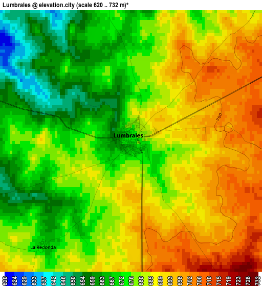
Below is the Elevation map of Lumbrales, which displays elevation range with different colors. Scale of the first map is from 620 to 732 m (2034 to 2402 ft) with average elevation of 680.6 meters (=2233 ft) [note 1]
These maps also provides idea of topography and contour of this city, they are displayed at different zoom levels. More info about maps, scale and edge coordinates you can find below images.
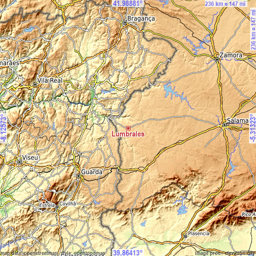
| \ | Map #1 | Topo.Map |
| Scale [m] | 620..732 m | × |
| Scale [ft] | 2034..2402 ft | × |
| Average | 680.6 m = 2233 ft | × |
| Width | 7.38 km = 4.6 mi | 236.2 km = 146.8 mi |
| Height | 7.38 km = 4.6 mi | 236.2 km = 146.8 mi |
| ↑Max Latitude | 40.9682° | 41.98881° |
| Latitude at center | 40.93501° | 40.93501° |
| ↓Min Latitude | 40.901803° | 39.86413° |
| ← Min Longitude | -6.763425° | -8.12573° |
| Longitude center | -6.71948° | -6.71948° |
| →Max Longitude | -6.675535° | -5.31323° |
Nearby cities:
Cities around Lumbrales sort by population:
• Hinojosa de Duero elevation 606 m
8.6 km,  312°
312°
• San Felices de los Gallegos 668 m
9.6 km,  174°
174°
• Saucelle 666 m
12.8 km,  347°
347°
• Bañobárez 750 m
13.2 km,  137°
137°
• Sobradillo 655 m
6.8 km,  253°
253°
• Cerralbo 676 m
11.9 km,  68°
68°
• Bermellar 642 m
8.3 km,  30°
30°
• Ahigal de los Aceiteros 641 m
7.3 km,  198°
198°
• Saldeana 664 m
11.6 km, 34°
• Olmedo de Camaces 710 m
10.1 km,  127°
127°
• Puerto Seguro 637 m
12.5 km, 196°
• La Bouza 614 m
12.7 km,  210°
210°
Multilingual:
 En español:
Lumbrales elevación 675 m.
 En France:
Lumbrales élévation 675 m.
 Auf Deutsch:
Lumbrales höhe über dem Meeresspiegel ist 675 m.

Sources and notes:
- [note 1] Map square and city borders are not equal. Map elevation data is calculated only from area inside that square.
- [src 1] Elevation data from geonames database provided with same terms of usage.
- [src 2] The elevation map of Lumbrales is generated using elevation data from NASA's 3 arcsec (90m) resolution SRTM data.
- [src 3] Base (background) map © OpenStreetMap contributors tiles are generated by Geofabrik and OpenTopoMap.
Copyright & License:
This Lumbrales Elevation Map is licensed under CC BY-SA. You may reuse any part from this page, if you give a proper credit by linking to this URL:
 More info on terms of use page.