Berberana elevation
Berberana (Castille and León, Provincia de Burgos), Spain elevation is 609 meters and Berberana elevation in feet is 1998 ft above sea level [src 1]. Berberana is a seat of a third-order administrative division (feature code) with elevation that is 6 meters (20 ft) bigger than average city elevation in Spain.
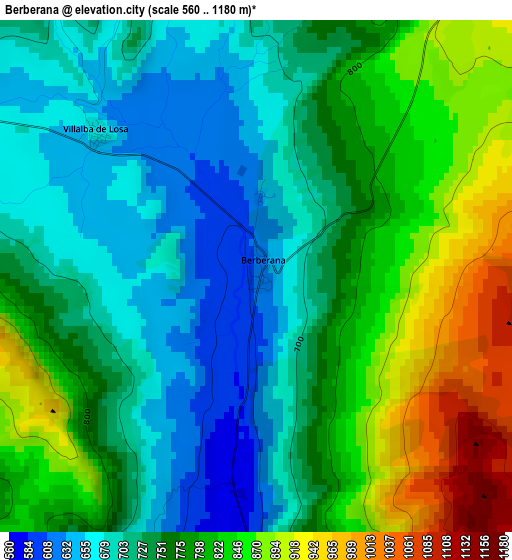
Below is the Elevation map of Berberana, which displays elevation range with different colors. Scale of the first map is from 560 to 1180 m (1837 to 3871 ft) with average elevation of 768 meters (=2520 ft) [note 1]
These maps also provides idea of topography and contour of this city, they are displayed at different zoom levels. More info about maps, scale and edge coordinates you can find below images.
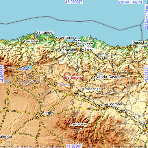
| \ | Map #1 | Topo.Map |
| Scale [m] | 560..1180 m | × |
| Scale [ft] | 1837..3871 ft | × |
| Average | 768 m = 2520 ft | × |
| Width | 7.16 km = 4.4 mi | 229 km = 142.3 mi |
| Height | 7.16 km = 4.4 mi | 229 km = 142.3 mi |
| ↑Max Latitude | 42.950014° | 43.93907° |
| Latitude at center | 42.91784° | 42.91784° |
| ↓Min Latitude | 42.885649° | 41.8794° |
| ← Min Longitude | -3.104575° | -4.46688° |
| Longitude center | -3.06063° | -3.06063° |
| →Max Longitude | -3.016685° | -1.65438° |
Nearby cities:
Cities around Berberana sort by population:
• Miranda de Ebro elevation 466 m
27.3 km,  160°
160°
• Laudio / Llodio 125 m
26.3 km,  17°
17°
• Amurrio 219 m
15.5 km, 18°
• Urduña / Orduña 293 m
9.5 km,  25°
25°
• Villasana de Mena 318 m
27.1 km,  318°
318°
• Murgia 617 m
20.1 km,  77°
77°
• Lezama 347 m
14.2 km, 30°
• Villanueva de Valdegovía 550 m
8.4 km,  201°
201°
• Frías 583 m
25.7 km,  227°
227°
• Santa Gadea del Cid 506 m
22.5 km,  179°
179°
• Armiñón 467 m
26.6 km,  144°
144°
• Encío 632 m
27.5 km, 184°
Multilingual:
 En español:
Berberana elevación 609 m.
 En France:
Berberana élévation 609 m.
 Auf Deutsch:
Berberana höhe über dem Meeresspiegel ist 609 m.

Sources and notes:
- [note 1] Map square and city borders are not equal. Map elevation data is calculated only from area inside that square.
- [src 1] Elevation data from geonames database provided with same terms of usage.
- [src 2] The elevation map of Berberana is generated using elevation data from NASA's 3 arcsec (90m) resolution SRTM data.
- [src 3] Base (background) map © OpenStreetMap contributors tiles are generated by Geofabrik and OpenTopoMap.
Copyright & License:
This Berberana Elevation Map is licensed under CC BY-SA. You may reuse any part from this page, if you give a proper credit by linking to this URL:
 More info on terms of use page.