Santa Gadea del Cid elevation
Santa Gadea del Cid (Castille and León, Provincia de Burgos), Spain elevation is 506 meters and Santa Gadea del Cid elevation in feet is 1660 ft above sea level [src 1]. Santa Gadea del Cid is a seat of a third-order administrative division (feature code) with elevation that is 97 meters (318 ft) smaller than average city elevation in Spain.
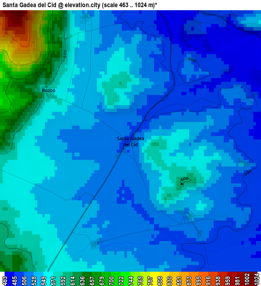
Below is the Elevation map of Santa Gadea del Cid, which displays elevation range with different colors. Scale of the first map is from 463 to 1024 m (1519 to 3360 ft) with average elevation of 546.2 meters (=1792 ft) [note 1]
These maps also provides idea of topography and contour of this city, they are displayed at different zoom levels. More info about maps, scale and edge coordinates you can find below images.
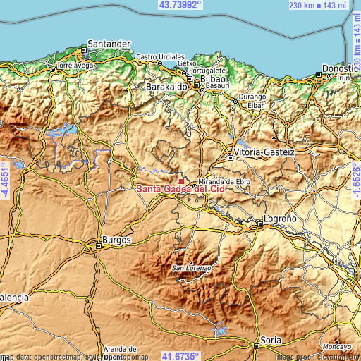
| \ | Map #1 | Topo.Map |
| Scale [m] | 463..1024 m | × |
| Scale [ft] | 1519..3360 ft | × |
| Average | 546.2 m = 1792 ft | × |
| Width | 7.18 km = 4.5 mi | 229.8 km = 142.8 mi |
| Height | 7.18 km = 4.5 mi | 229.8 km = 142.8 mi |
| ↑Max Latitude | 42.74759° | 43.73992° |
| Latitude at center | 42.71531° | 42.71531° |
| ↓Min Latitude | 42.683014° | 41.6735° |
| ← Min Longitude | -3.102795° | -4.4651° |
| Longitude center | -3.05885° | -3.05885° |
| →Max Longitude | -3.014905° | -1.6526° |
Nearby cities:
Cities around Santa Gadea del Cid sort by population:
• Miranda de Ebro elevation 466 m
9.7 km,  109°
109°
• Pancorbo 641 m
10 km,  205°
205°
• Bugedo 537 m
8.1 km,  155°
155°
• Cubo de Bureba 685 m
14.7 km,  235°
235°
• Miraveche 806 m
12.4 km,  248°
248°
• Foncea 694 m
11.2 km,  171°
171°
• Ameyugo 554 m
6.6 km,  182°
182°
• Galbárruli 651 m
13.1 km,  142°
142°
• Altable 710 m
12.6 km,  186°
186°
• Villanueva de Teba 725 m
11.3 km,  229°
229°
• Encío 632 m
5.4 km,  204°
204°
• Cellorigo 768 m
10.9 km,  153°
153°
Multilingual:
 En español:
Santa Gadea del Cid elevación 506 m.
 En France:
Santa Gadea del Cid élévation 506 m.
 Auf Deutsch:
Santa Gadea del Cid höhe über dem Meeresspiegel ist 506 m.
 На русском:
Santa Gadea del Cid высота над уровнем моря 506 м
Sources and notes:
- [note 1] Map square and city borders are not equal. Map elevation data is calculated only from area inside that square.
- [src 1] Elevation data from geonames database provided with same terms of usage.
- [src 2] The elevation map of Santa Gadea del Cid is generated using elevation data from NASA's 3 arcsec (90m) resolution SRTM data.
- [src 3] Base (background) map © OpenStreetMap contributors tiles are generated by Geofabrik and OpenTopoMap.
Copyright & License:
This Santa Gadea del Cid Elevation Map is licensed under CC BY-SA. You may reuse any part from this page, if you give a proper credit by linking to this URL:
 More info on terms of use page.