Berga elevation
Berga (Catalonia, Província de Barcelona), Spain elevation is 720 meters and Berga elevation in feet is 2362 ft above sea level [src 1]. Berga is a populated place (feature code) with elevation that is 117 meters (384 ft) bigger than average city elevation in Spain.
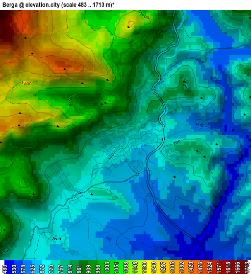
Below is the Elevation map of Berga, which displays elevation range with different colors. Scale of the first map is from 483 to 1713 m (1585 to 5620 ft) with average elevation of 824.5 meters (=2705 ft) [note 1]
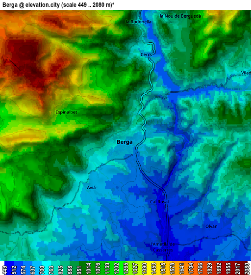
These maps also provides idea of topography and contour of this city, they are displayed at different zoom levels. More info about maps, scale and edge coordinates you can find below images.
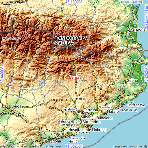
| \ | Map #1 | Map #2 | Topo.Map |
| Scale [m] | 483..1713 m | 449..2080 m | × |
| Scale [ft] | 1585..5620 ft | 1473..6824 ft | × |
| Average | 824.5 m = 2705 ft | 937.5 m = 3076 ft | × |
| Width | 7.25 km = 4.5 mi | 14.5 km = 9 mi | 232 km = 144.2 mi |
| Height | 7.25 km = 4.5 mi | 14.5 km = 9 mi | 232 km = 144.2 mi |
| ↑Max Latitude | 42.136886° | 42.169465° | 43.13903° |
| Latitude at center | 42.10429° | 42.10429° | 42.10429° |
| ↓Min Latitude | 42.071677° | 42.039048° | 41.05238° |
| ← Min Longitude | 1.802335° | 1.758389° | 0.44003° |
| Longitude center | 1.84628° | 1.84628° | 1.84628° |
| →Max Longitude | 1.890225° | 1.934171° | 3.25253° |
Nearby cities:
Cities around Berga sort by population:
• Gironella elevation 455 m
8.3 km,  160°
160°
• Sant Julià de Cerdanyola 965 m
13.8 km,  16°
16°
• Sagàs 727 m
11.6 km,  121°
121°
• Puig-reig 423 m
15.6 km,  168°
168°
• Guardiola de Berguedà 734 m
14.7 km,  9°
9°
• Borredà 859 m
12.7 km,  74°
74°
• Vallcebre 1126 m
11.3 km,  348°
348°
• Capolat 1264 m
8.2 km,  248°
248°
• Vilada 727 m
7.9 km,  62°
62°
• Castellar del Riu 1537 m
6.3 km,  289°
289°
• Olvan 608 m
6.1 km,  133°
133°
• Avià 608 m
4.2 km,  175°
175°
Multilingual:
 En español:
Berga elevación 720 m.
 En France:
Berga élévation 720 m.


Sources and notes:
- [note 1] Map square and city borders are not equal. Map elevation data is calculated only from area inside that square.
- [src 1] Elevation data from geonames database provided with same terms of usage.
- [src 2] The elevation map of Berga is generated using elevation data from NASA's 3 arcsec (90m) resolution SRTM data.
- [src 3] Base (background) map © OpenStreetMap contributors tiles are generated by Geofabrik and OpenTopoMap.
Copyright & License:
This Berga Elevation Map is licensed under CC BY-SA. You may reuse any part from this page, if you give a proper credit by linking to this URL:
 More info on terms of use page.