Vallcebre elevation
Vallcebre (Catalonia, Província de Barcelona), Spain elevation is 1126 meters and Vallcebre elevation in feet is 3694 ft above sea level [src 1]. Vallcebre is a seat of a third-order administrative division (feature code) with elevation that is 523 meters (1716 ft) bigger than average city elevation in Spain.
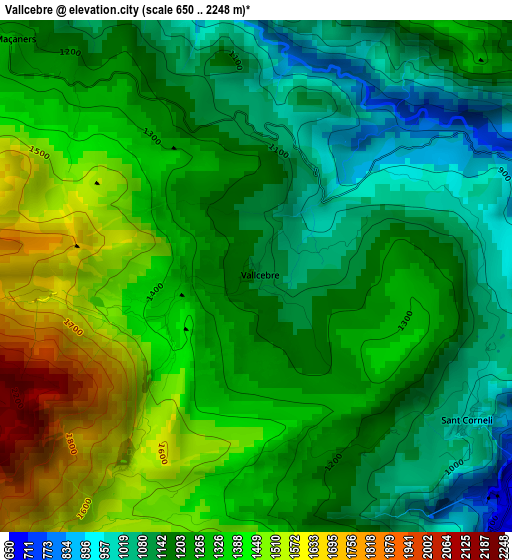
Below is the Elevation map of Vallcebre, which displays elevation range with different colors. Scale of the first map is from 650 to 2248 m (2133 to 7375 ft) with average elevation of 1264.5 meters (=4149 ft) [note 1]
These maps also provides idea of topography and contour of this city, they are displayed at different zoom levels. More info about maps, scale and edge coordinates you can find below images.
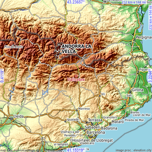
| \ | Map #1 | Topo.Map |
| Scale [m] | 650..2248 m | × |
| Scale [ft] | 2133..7375 ft | × |
| Average | 1264.5 m = 4149 ft | × |
| Width | 7.24 km = 4.5 mi | 231.7 km = 144 mi |
| Height | 7.24 km = 4.5 mi | 231.6 km = 143.9 mi |
| ↑Max Latitude | 42.236015° | 43.23657° |
| Latitude at center | 42.20347° | 42.20347° |
| ↓Min Latitude | 42.170909° | 41.15319° |
| ← Min Longitude | 1.774205° | 0.4119° |
| Longitude center | 1.81815° | 1.81815° |
| →Max Longitude | 1.862095° | 3.2244° |
Nearby cities:
Cities around Vallcebre sort by population:
• Berga elevation 720 m
11.3 km,  168°
168°
• Bagà 794 m
6.5 km,  32°
32°
• Sant Julià de Cerdanyola 965 m
6.6 km,  70°
70°
• Gósol 1437 m
13.5 km,  285°
285°
• Borredà 859 m
16.4 km,  117°
117°
• Riu de Cerdanya 1180 m
15.8 km,  2°
2°
• Avià 608 m
15.4 km, 170°
• Capolat 1264 m
15 km,  200°
200°
• Vilada 727 m
11.9 km,  128°
128°
• Castellar del Riu 1537 m
9.7 km, 202°
• Saldes 1365 m
7.7 km,  295°
295°
• Guardiola de Berguedà 734 m
6 km,  54°
54°
Multilingual:
 En español:
Vallcebre elevación 1126 m.
 En France:
Vallcebre élévation 1126 m.
 Auf Deutsch:
Vallcebre höhe über dem Meeresspiegel ist 1126 m.

Sources and notes:
- [note 1] Map square and city borders are not equal. Map elevation data is calculated only from area inside that square.
- [src 1] Elevation data from geonames database provided with same terms of usage.
- [src 2] The elevation map of Vallcebre is generated using elevation data from NASA's 3 arcsec (90m) resolution SRTM data.
- [src 3] Base (background) map © OpenStreetMap contributors tiles are generated by Geofabrik and OpenTopoMap.
Copyright & License:
This Vallcebre Elevation Map is licensed under CC BY-SA. You may reuse any part from this page, if you give a proper credit by linking to this URL:
 More info on terms of use page.