Gironella elevation
Gironella (Catalonia, Província de Barcelona), Spain elevation is 455 meters and Gironella elevation in feet is 1493 ft above sea level [src 1]. Gironella is a populated place (feature code) with elevation that is 148 meters (486 ft) smaller than average city elevation in Spain.
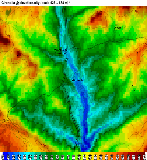
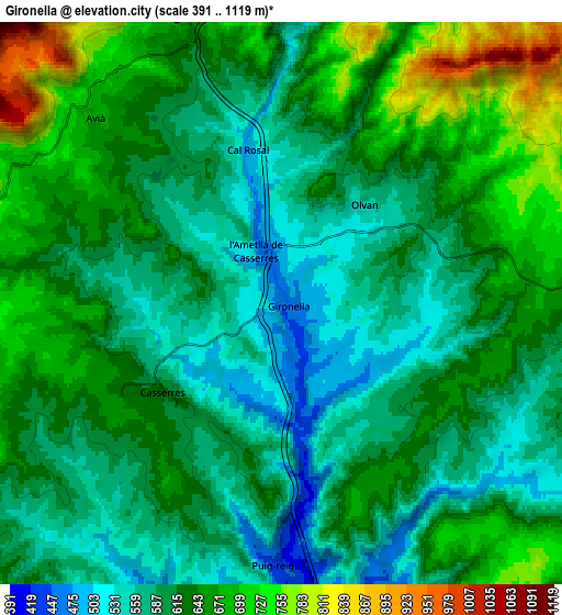
Below is the Elevation map of Gironella, which displays elevation range with different colors. Scale of the first map is from 423 to 678 m (1388 to 2224 ft) with average elevation of 540 meters (=1772 ft) [note 1]
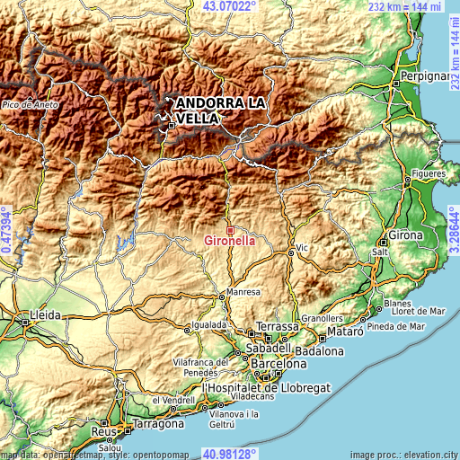
These maps also provides idea of topography and contour of this city, they are displayed at different zoom levels. More info about maps, scale and edge coordinates you can find below images.
| \ | Map #1 | Map #2 | Topo.Map |
| Scale [m] | 423..678 m | 391..1119 m | × |
| Scale [ft] | 1388..2224 ft | 1283..3671 ft | × |
| Average | 540 m = 1772 ft | 619.6 m = 2033 ft | × |
| Width | 7.26 km = 4.5 mi | 14.52 km = 9 mi | 232.3 km = 144.3 mi |
| Height | 7.26 km = 4.5 mi | 14.52 km = 9 mi | 232.3 km = 144.3 mi |
| ↑Max Latitude | 42.066962° | 42.099577° | 43.07022° |
| Latitude at center | 42.03433° | 42.03433° | 42.03433° |
| ↓Min Latitude | 42.001682° | 41.969016° | 40.98128° |
| ← Min Longitude | 1.836245° | 1.792299° | 0.47394° |
| Longitude center | 1.88019° | 1.88019° | 1.88019° |
| →Max Longitude | 1.924135° | 1.968081° | 3.28644° |
Nearby cities:
Cities around Gironella sort by population:
• Berga elevation 720 m
8.3 km,  340°
340°
• Navàs 376 m
14.9 km,  180°
180°
• Sagàs 727 m
7.4 km,  76°
76°
• Sant Feliu Sasserra 527 m
15.8 km,  126°
126°
• Borredà 859 m
14.7 km,  39°
39°
• Castellar del Riu 1537 m
13.2 km,  318°
318°
• Prats de Lluçanès 717 m
12.8 km,  98°
98°
• Vilada 727 m
12.2 km,  20°
20°
• Capolat 1264 m
11.5 km,  294°
294°
• Puig-reig 423 m
7.5 km, 178°
• Avià 608 m
4.4 km,  325°
325°
• Olvan 608 m
4 km, 24°
Multilingual:
 En español:
Gironella elevación 455 m.
 En France:
Gironella élévation 455 m.
 Auf Deutsch:
Gironella höhe über dem Meeresspiegel ist 455 m.

Sources and notes:
- [note 1] Map square and city borders are not equal. Map elevation data is calculated only from area inside that square.
- [src 1] Elevation data from geonames database provided with same terms of usage.
- [src 2] The elevation map of Gironella is generated using elevation data from NASA's 3 arcsec (90m) resolution SRTM data.
- [src 3] Base (background) map © OpenStreetMap contributors tiles are generated by Geofabrik and OpenTopoMap.
Copyright & License:
This Gironella Elevation Map is licensed under CC BY-SA. You may reuse any part from this page, if you give a proper credit by linking to this URL:
 More info on terms of use page.