Biel elevation
Biel (Aragon, Provincia de Zaragoza), Spain elevation is 766 meters and Biel elevation in feet is 2513 ft above sea level [src 1]. Biel is a seat of a third-order administrative division (feature code) with elevation that is 163 meters (535 ft) bigger than average city elevation in Spain.
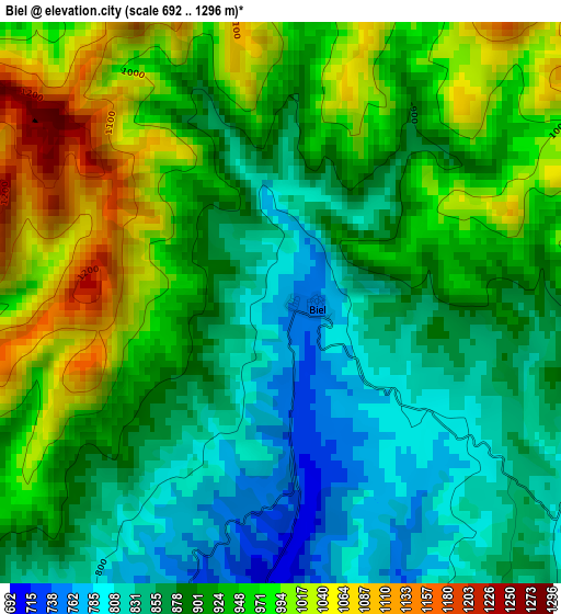
Below is the Elevation map of Biel, which displays elevation range with different colors. Scale of the first map is from 692 to 1296 m (2270 to 4252 ft) with average elevation of 914.9 meters (=3002 ft) [note 1]
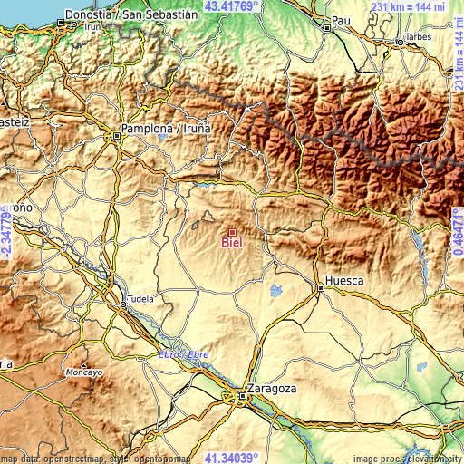
These maps also provides idea of topography and contour of this city, they are displayed at different zoom levels. More info about maps, scale and edge coordinates you can find below images.
| \ | Map #1 | Topo.Map |
| Scale [m] | 692..1296 m | × |
| Scale [ft] | 2270..4252 ft | × |
| Average | 914.9 m = 3002 ft | × |
| Width | 7.22 km = 4.5 mi | 231 km = 143.5 mi |
| Height | 7.22 km = 4.5 mi | 231 km = 143.5 mi |
| ↑Max Latitude | 42.42008° | 43.41769° |
| Latitude at center | 42.38763° | 42.38763° |
| ↓Min Latitude | 42.355164° | 41.34039° |
| ← Min Longitude | -0.985485° | -2.34779° |
| Longitude center | -0.94154° | -0.94154° |
| →Max Longitude | -0.897595° | 0.46471° |
Nearby cities:
Cities around Biel sort by population:
• Uncastillo elevation 614 m
15.7 km,  258°
258°
• Luesia 794 m
7.1 km,  253°
253°
• Bailo 722 m
17.2 km,  38°
38°
• Agüero 688 m
12.7 km,  106°
106°
• Santa Eulalia de Gállego 509 m
18.6 km,  126°
126°
• Orés 631 m
13.2 km,  201°
201°
• Lobera de Onsella 668 m
12.1 km,  326°
326°
• Longás 750 m
10.4 km,  3°
3°
• Isuerre 612 m
14.4 km,  320°
320°
• Bagüés 825 m
18 km,  358°
358°
• Petilla de Aragón 935 m
16 km,  295°
295°
• Asin 631 m
14.5 km,  216°
216°
Multilingual:
 En español:
Biel elevación 766 m.
 En France:
Biel élévation 766 m.


Sources and notes:
- [note 1] Map square and city borders are not equal. Map elevation data is calculated only from area inside that square.
- [src 1] Elevation data from geonames database provided with same terms of usage.
- [src 2] The elevation map of Biel is generated using elevation data from NASA's 3 arcsec (90m) resolution SRTM data.
- [src 3] Base (background) map © OpenStreetMap contributors tiles are generated by Geofabrik and OpenTopoMap.
Copyright & License:
This Biel Elevation Map is licensed under CC BY-SA. You may reuse any part from this page, if you give a proper credit by linking to this URL:
 More info on terms of use page.