Boñar elevation
Boñar (Castille and León, Provincia de León), Spain elevation is 975 meters and Boñar elevation in feet is 3199 ft above sea level [src 1]. Boñar is a seat of a third-order administrative division (feature code) with elevation that is 372 meters (1220 ft) bigger than average city elevation in Spain.
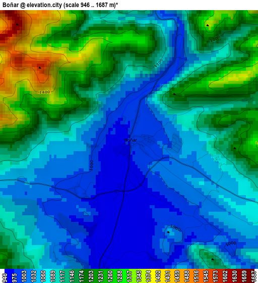
Below is the Elevation map of Boñar, which displays elevation range with different colors. Scale of the first map is from 946 to 1687 m (3104 to 5535 ft) with average elevation of 1110.9 meters (=3645 ft) [note 1]
These maps also provides idea of topography and contour of this city, they are displayed at different zoom levels. More info about maps, scale and edge coordinates you can find below images.
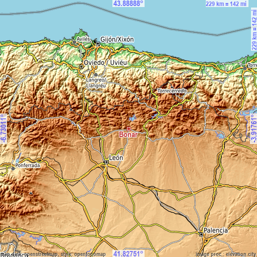
| \ | Map #1 | Topo.Map |
| Scale [m] | 946..1687 m | × |
| Scale [ft] | 3104..5535 ft | × |
| Average | 1110.9 m = 3645 ft | × |
| Width | 7.16 km = 4.4 mi | 229.2 km = 142.4 mi |
| Height | 7.16 km = 4.4 mi | 229.2 km = 142.4 mi |
| ↑Max Latitude | 42.899001° | 43.88888° |
| Latitude at center | 42.8668° | 42.8668° |
| ↓Min Latitude | 42.834582° | 41.82751° |
| ← Min Longitude | -5.367805° | -6.73011° |
| Longitude center | -5.32386° | -5.32386° |
| →Max Longitude | -5.279915° | -3.91761° |
Nearby cities:
Cities around Boñar sort by population:
• Cistierna elevation 945 m
17.6 km,  113°
113°
• Sabero 985 m
14.7 km,  103°
103°
• Matallana de Torío 1020 m
16 km,  269°
269°
• Garrafe de Torío 916 m
22.1 km,  227°
227°
• Crémenes 995 m
15.2 km,  74°
74°
• Puebla de Lillo 1136 m
16.1 km,  14°
14°
• Santa Colomba de Curueño 927 m
14.8 km,  209°
209°
• Vegaquemada 938 m
5.4 km,  187°
187°
• Valdepiélago 1040 m
6 km, 272°
• Cármenes 1162 m
22.7 km,  296°
296°
• Vegacervera 1057 m
17.4 km,  277°
277°
• Reyero 1152 m
13.7 km,  48°
48°
Multilingual:
 En español:
Boñar elevación 975 m.
 En France:
Boñar élévation 975 m.


Sources and notes:
- [note 1] Map square and city borders are not equal. Map elevation data is calculated only from area inside that square.
- [src 1] Elevation data from geonames database provided with same terms of usage.
- [src 2] The elevation map of Boñar is generated using elevation data from NASA's 3 arcsec (90m) resolution SRTM data.
- [src 3] Base (background) map © OpenStreetMap contributors tiles are generated by Geofabrik and OpenTopoMap.
Copyright & License:
This Boñar Elevation Map is licensed under CC BY-SA. You may reuse any part from this page, if you give a proper credit by linking to this URL:
 More info on terms of use page.