Sabero elevation
Sabero (Castille and León, Provincia de León), Spain elevation is 985 meters and Sabero elevation in feet is 3232 ft above sea level [src 1]. Sabero is a seat of a third-order administrative division (feature code) with elevation that is 382 meters (1253 ft) bigger than average city elevation in Spain.
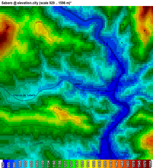
Below is the Elevation map of Sabero, which displays elevation range with different colors. Scale of the first map is from 929 to 1596 m (3048 to 5236 ft) with average elevation of 1127.3 meters (=3698 ft) [note 1]
These maps also provides idea of topography and contour of this city, they are displayed at different zoom levels. More info about maps, scale and edge coordinates you can find below images.
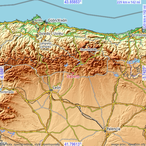
| \ | Map #1 | Topo.Map |
| Scale [m] | 929..1596 m | × |
| Scale [ft] | 3048..5236 ft | × |
| Average | 1127.3 m = 3698 ft | × |
| Width | 7.17 km = 4.5 mi | 229.3 km = 142.5 mi |
| Height | 7.17 km = 4.5 mi | 229.3 km = 142.5 mi |
| ↑Max Latitude | 42.868147° | 43.85853° |
| Latitude at center | 42.83593° | 42.83593° |
| ↓Min Latitude | 42.803696° | 41.79613° |
| ← Min Longitude | -5.192695° | -6.555° |
| Longitude center | -5.14875° | -5.14875° |
| →Max Longitude | -5.104805° | -3.7425° |
Nearby cities:
Cities around Sabero sort by population:
• Cistierna elevation 945 m
4 km,  153°
153°
• Boñar 975 m
14.7 km,  283°
283°
• Valderrueda 1034 m
16.6 km,  97°
97°
• Crémenes 995 m
7.5 km,  3°
3°
• Cubillas de Rueda 885 m
20.1 km,  186°
186°
• Riaño 1126 m
19.6 km,  37°
37°
• Vegaquemada 938 m
15.1 km,  262°
262°
• Prioro 1109 m
16.5 km,  66°
66°
• Valdepiélago 1040 m
20.6 km, 280°
• Cebanico 957 m
15.9 km,  140°
140°
• Reyero 1152 m
13.2 km,  341°
341°
• Prado de la Guzpeña 1047 m
11.6 km,  120°
120°
Multilingual:
 En español:
Sabero elevación 985 m.
 En France:
Sabero élévation 985 m.


Sources and notes:
- [note 1] Map square and city borders are not equal. Map elevation data is calculated only from area inside that square.
- [src 1] Elevation data from geonames database provided with same terms of usage.
- [src 2] The elevation map of Sabero is generated using elevation data from NASA's 3 arcsec (90m) resolution SRTM data.
- [src 3] Base (background) map © OpenStreetMap contributors tiles are generated by Geofabrik and OpenTopoMap.
Copyright & License:
This Sabero Elevation Map is licensed under CC BY-SA. You may reuse any part from this page, if you give a proper credit by linking to this URL:
 More info on terms of use page.