Riaño elevation
Riaño (Castille and León, Provincia de León), Spain elevation is 1126 meters and Riaño elevation in feet is 3694 ft above sea level [src 1]. Riaño is a seat of a third-order administrative division (feature code) with elevation that is 523 meters (1716 ft) bigger than average city elevation in Spain.
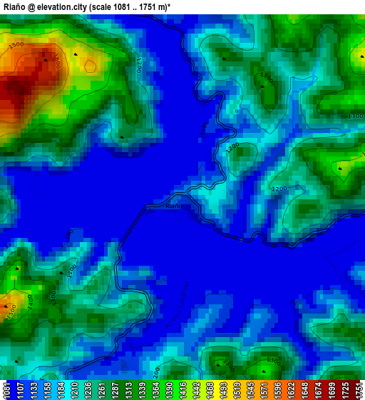
Below is the Elevation map of Riaño, which displays elevation range with different colors. Scale of the first map is from 1081 to 1751 m (3547 to 5745 ft) with average elevation of 1206.3 meters (=3958 ft) [note 1]
These maps also provides idea of topography and contour of this city, they are displayed at different zoom levels. More info about maps, scale and edge coordinates you can find below images.
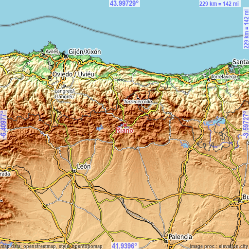
| \ | Map #1 | Topo.Map |
| Scale [m] | 1081..1751 m | × |
| Scale [ft] | 3547..5745 ft | × |
| Average | 1206.3 m = 3958 ft | × |
| Width | 7.15 km = 4.4 mi | 228.8 km = 142.2 mi |
| Height | 7.15 km = 4.4 mi | 228.8 km = 142.2 mi |
| ↑Max Latitude | 43.009193° | 43.99729° |
| Latitude at center | 42.97705° | 42.97705° |
| ↓Min Latitude | 42.94489° | 41.9396° |
| ← Min Longitude | -5.047465° | -6.40977° |
| Longitude center | -5.00352° | -5.00352° |
| →Max Longitude | -4.959575° | -3.59727° |
Nearby cities:
Cities around Riaño sort by population:
• Velilla del Río Carrión elevation 1121 m
21.1 km,  142°
142°
• Sabero 985 m
19.6 km,  217°
217°
• Valderrueda 1034 m
18.5 km,  165°
165°
• Crémenes 995 m
14 km,  234°
234°
• Boca de Huérgano 1112 m
6.5 km,  94°
94°
• Posada de Valdeón 914 m
20.5 km,  19°
19°
• Prioro 1109 m
9.7 km,  160°
160°
• Burón 1107 m
6.6 km,  323°
323°
• Oseja de Sajambre 759 m
18 km,  351°
351°
• Maraña 1247 m
16.3 km,  299°
299°
• Reyero 1152 m
16.2 km,  258°
258°
• Acebedo 1152 m
11.5 km,  307°
307°
Multilingual:
 En español:
Riaño elevación 1126 m.
 En France:
Riaño élévation 1126 m.


Sources and notes:
- [note 1] Map square and city borders are not equal. Map elevation data is calculated only from area inside that square.
- [src 1] Elevation data from geonames database provided with same terms of usage.
- [src 2] The elevation map of Riaño is generated using elevation data from NASA's 3 arcsec (90m) resolution SRTM data.
- [src 3] Base (background) map © OpenStreetMap contributors tiles are generated by Geofabrik and OpenTopoMap.
Copyright & License:
This Riaño Elevation Map is licensed under CC BY-SA. You may reuse any part from this page, if you give a proper credit by linking to this URL:
 More info on terms of use page.