Camañas elevation
Camañas (Aragon, Provincia de Teruel), Spain elevation is 1241 meters and Camañas elevation in feet is 4072 ft above sea level [src 1]. Camañas is a seat of a third-order administrative division (feature code) with elevation that is 638 meters (2093 ft) bigger than average city elevation in Spain.
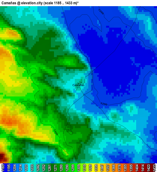
Below is the Elevation map of Camañas, which displays elevation range with different colors. Scale of the first map is from 1185 to 1433 m (3888 to 4701 ft) with average elevation of 1244.3 meters (=4082 ft) [note 1]
These maps also provides idea of topography and contour of this city, they are displayed at different zoom levels. More info about maps, scale and edge coordinates you can find below images.
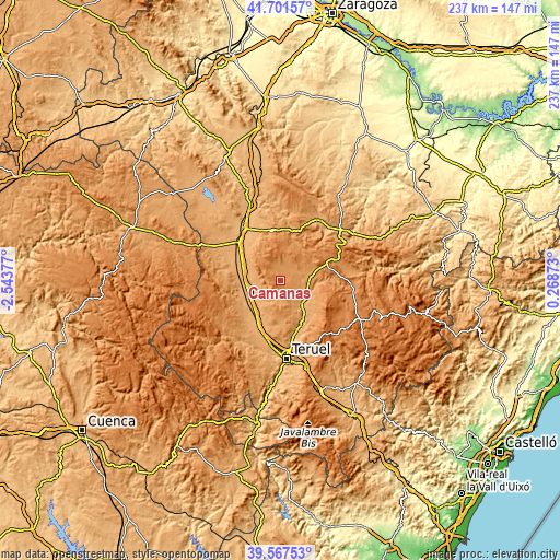
| \ | Map #1 | Topo.Map |
| Scale [m] | 1185..1433 m | × |
| Scale [ft] | 3888..4701 ft | × |
| Average | 1244.3 m = 4082 ft | × |
| Width | 7.42 km = 4.6 mi | 237.3 km = 147.5 mi |
| Height | 7.42 km = 4.6 mi | 237.3 km = 147.5 mi |
| ↑Max Latitude | 40.676417° | 41.70157° |
| Latitude at center | 40.64308° | 40.64308° |
| ↓Min Latitude | 40.609727° | 39.56753° |
| ← Min Longitude | -1.181465° | -2.54377° |
| Longitude center | -1.13752° | -1.13752° |
| →Max Longitude | -1.093575° | 0.26873° |
Nearby cities:
Cities around Camañas sort by population:
• Alfambra elevation 1044 m
13.9 km,  140°
140°
• Perales del Alfambra 1170 m
11.5 km,  95°
95°
• Argente 1249 m
5.5 km,  337°
337°
• Visiedo 1187 m
5.8 km,  35°
35°
• Orrios 1065 m
14.1 km,  115°
115°
• Fuentes Calientes 1252 m
15.7 km,  66°
66°
• Rillo 1273 m
14.8 km,  53°
53°
• Singra 1031 m
14.7 km,  275°
275°
• Lidón 1219 m
8.5 km,  14°
14°
• Bueña 1231 m
13.2 km,  303°
303°
• Rubielos de la Cérida 1230 m
15.5 km, 335°
• Aguatón 1234 m
8.8 km,  291°
291°
Multilingual:
 En español:
Camañas elevación 1241 m.
 En France:
Camañas élévation 1241 m.
 Auf Deutsch:
Camañas höhe über dem Meeresspiegel ist 1241 m.

Sources and notes:
- [note 1] Map square and city borders are not equal. Map elevation data is calculated only from area inside that square.
- [src 1] Elevation data from geonames database provided with same terms of usage.
- [src 2] The elevation map of Camañas is generated using elevation data from NASA's 3 arcsec (90m) resolution SRTM data.
- [src 3] Base (background) map © OpenStreetMap contributors tiles are generated by Geofabrik and OpenTopoMap.
Copyright & License:
This Camañas Elevation Map is licensed under CC BY-SA. You may reuse any part from this page, if you give a proper credit by linking to this URL:
 More info on terms of use page.