Camarena elevation
Camarena (Castille-La Mancha, Province of Toledo), Spain elevation is 576 meters and Camarena elevation in feet is 1890 ft above sea level [src 1]. Camarena is a seat of a third-order administrative division (feature code) with elevation that is 27 meters (89 ft) smaller than average city elevation in Spain.
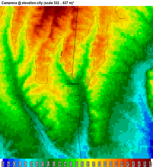
Below is the Elevation map of Camarena, which displays elevation range with different colors. Scale of the first map is from 532 to 637 m (1745 to 2090 ft) with average elevation of 581.1 meters (=1906 ft) [note 1]
These maps also provides idea of topography and contour of this city, they are displayed at different zoom levels. More info about maps, scale and edge coordinates you can find below images.
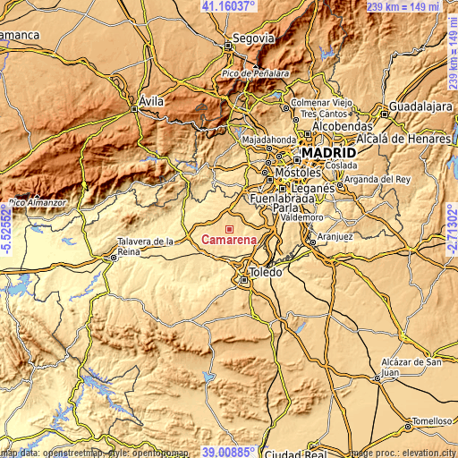
| \ | Map #1 | Topo.Map |
| Scale [m] | 532..637 m | × |
| Scale [ft] | 1745..2090 ft | × |
| Average | 581.1 m = 1906 ft | × |
| Width | 7.48 km = 4.6 mi | 239.2 km = 148.6 mi |
| Height | 7.48 km = 4.6 mi | 239.2 km = 148.6 mi |
| ↑Max Latitude | 40.12672° | 41.16037° |
| Latitude at center | 40.09311° | 40.09311° |
| ↓Min Latitude | 40.059484° | 39.00885° |
| ← Min Longitude | -4.163215° | -5.52552° |
| Longitude center | -4.11927° | -4.11927° |
| →Max Longitude | -4.075325° | -2.71302° |
Nearby cities:
Cities around Camarena sort by population:
• Fuensalida elevation 592 m
8.7 km,  239°
239°
• Casarrubios del Monte 620 m
12.6 km,  34°
34°
• Valmojado 654 m
12.6 km,  10°
10°
• Recas 571 m
11.8 km,  112°
112°
• Santa Cruz del Retamar 598 m
10.8 km,  285°
285°
• Portillo de Toledo 593 m
9.8 km,  250°
250°
• Chozas de Canales 548 m
6.5 km,  83°
83°
• La Torre de Esteban Hambrán 568 m
11.8 km,  316°
316°
• Las Ventas de Retamosa 625 m
6.9 km,  3°
3°
• Arcicóllar 548 m
4.2 km,  176°
176°
• Huecas 555 m
11.1 km,  215°
215°
• Camarenilla 512 m
9.2 km,  156°
156°
Multilingual:
 En español:
Camarena elevación 576 m.
 En France:
Camarena élévation 576 m.
 Auf Deutsch:
Camarena höhe über dem Meeresspiegel ist 576 m.

Sources and notes:
- [note 1] Map square and city borders are not equal. Map elevation data is calculated only from area inside that square.
- [src 1] Elevation data from geonames database provided with same terms of usage.
- [src 2] The elevation map of Camarena is generated using elevation data from NASA's 3 arcsec (90m) resolution SRTM data.
- [src 3] Base (background) map © OpenStreetMap contributors tiles are generated by Geofabrik and OpenTopoMap.
Copyright & License:
This Camarena Elevation Map is licensed under CC BY-SA. You may reuse any part from this page, if you give a proper credit by linking to this URL:
 More info on terms of use page.