Portillo de Toledo elevation
Portillo de Toledo (Castille-La Mancha, Province of Toledo), Spain elevation is 593 meters and Portillo de Toledo elevation in feet is 1946 ft above sea level [src 1]. Portillo de Toledo is a seat of a third-order administrative division (feature code) with elevation that is 10 meters (33 ft) smaller than average city elevation in Spain.
Below is the Elevation map of Portillo de Toledo, which displays elevation range with different colors. Scale of the first map is from 541 to 603 m (1775 to 1978 ft) with average elevation of 579.1 meters (=1900 ft) [note 1]
These maps also provides idea of topography and contour of this city, they are displayed at different zoom levels. More info about maps, scale and edge coordinates you can find below images.
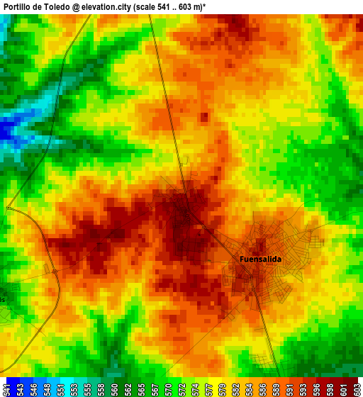
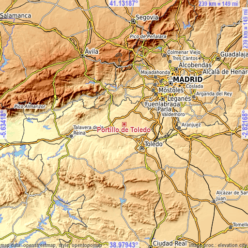
| \ | Map #1 | Topo.Map |
| Scale [m] | 541..603 m | × |
| Scale [ft] | 1775..1978 ft | × |
| Average | 579.1 m = 1900 ft | × |
| Width | 7.48 km = 4.6 mi | 239.3 km = 148.7 mi |
| Height | 7.48 km = 4.6 mi | 239.3 km = 148.7 mi |
| ↑Max Latitude | 40.097774° | 41.13187° |
| Latitude at center | 40.06415° | 40.06415° |
| ↓Min Latitude | 40.030509° | 38.97943° |
| ← Min Longitude | -4.271875° | -5.63418° |
| Longitude center | -4.22793° | -4.22793° |
| →Max Longitude | -4.183985° | -2.82168° |
Nearby cities:
Cities around Portillo de Toledo sort by population:
• Torrijos elevation 531 m
10.3 km,  207°
207°
• Fuensalida 592 m
2.2 km,  125°
125°
• Camarena 576 m
9.8 km,  70°
70°
• Santa Cruz del Retamar 598 m
6.2 km,  349°
349°
• La Torre de Esteban Hambrán 568 m
11.7 km,  5°
5°
• Quismondo 549 m
9.4 km,  299°
299°
• Arcicóllar 548 m
9.5 km,  96°
96°
• Rielves 498 m
11.7 km,  165°
165°
• Huecas 555 m
6.4 km,  154°
154°
• Maqueda 484 m
12.1 km,  271°
271°
• Barcience 517 m
9 km,  183°
183°
• Novés 555 m
4.4 km,  245°
245°
Multilingual:
 En español:
Portillo de Toledo elevación 593 m.
 En France:
Portillo de Toledo élévation 593 m.
 Auf Deutsch:
Portillo de Toledo höhe über dem Meeresspiegel ist 593 m.
 На русском:
Portillo de Toledo высота над уровнем моря 593 м
Sources and notes:
- [note 1] Map square and city borders are not equal. Map elevation data is calculated only from area inside that square.
- [src 1] Elevation data from geonames database provided with same terms of usage.
- [src 2] The elevation map of Portillo de Toledo is generated using elevation data from NASA's 3 arcsec (90m) resolution SRTM data.
- [src 3] Base (background) map © OpenStreetMap contributors tiles are generated by Geofabrik and OpenTopoMap.
Copyright & License:
This Portillo de Toledo Elevation Map is licensed under CC BY-SA. You may reuse any part from this page, if you give a proper credit by linking to this URL:
 More info on terms of use page.