Huecas elevation
Huecas (Castille-La Mancha, Province of Toledo), Spain elevation is 555 meters and Huecas elevation in feet is 1821 ft above sea level [src 1]. Huecas is a seat of a third-order administrative division (feature code) with elevation that is 48 meters (157 ft) smaller than average city elevation in Spain.
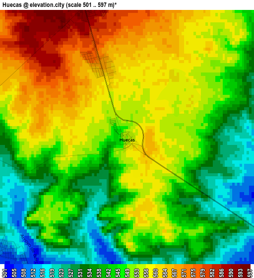
Below is the Elevation map of Huecas, which displays elevation range with different colors. Scale of the first map is from 501 to 597 m (1644 to 1959 ft) with average elevation of 548.7 meters (=1800 ft) [note 1]
These maps also provides idea of topography and contour of this city, they are displayed at different zoom levels. More info about maps, scale and edge coordinates you can find below images.
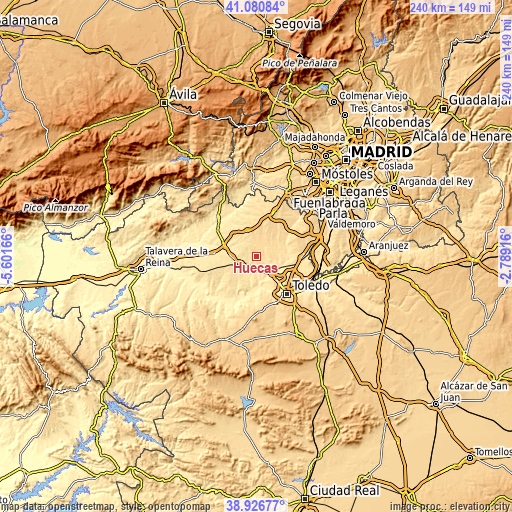
| \ | Map #1 | Topo.Map |
| Scale [m] | 501..597 m | × |
| Scale [ft] | 1644..1959 ft | × |
| Average | 548.7 m = 1800 ft | × |
| Width | 7.48 km = 4.6 mi | 239.5 km = 148.8 mi |
| Height | 7.48 km = 4.6 mi | 239.5 km = 148.8 mi |
| ↑Max Latitude | 40.04595° | 41.08084° |
| Latitude at center | 40.0123° | 40.0123° |
| ↓Min Latitude | 39.978634° | 38.92677° |
| ← Min Longitude | -4.239355° | -5.60166° |
| Longitude center | -4.19541° | -4.19541° |
| →Max Longitude | -4.151465° | -2.78916° |
Nearby cities:
Cities around Huecas sort by population:
• Torrijos elevation 531 m
8.2 km,  245°
245°
• Fuensalida 592 m
4.6 km,  347°
347°
• Camarena 576 m
11.1 km,  35°
35°
• Santa Cruz del Retamar 598 m
12.5 km,  341°
341°
• Portillo de Toledo 593 m
6.4 km,  334°
334°
• Gerindote 551 m
10.5 km,  240°
240°
• Villamiel de Toledo 483 m
7.9 km,  131°
131°
• Arcicóllar 548 m
8.2 km,  54°
54°
• Rielves 498 m
5.6 km,  177°
177°
• Camarenilla 512 m
10.2 km,  87°
87°
• Barcience 517 m
4.6 km,  226°
226°
• Novés 555 m
7.8 km,  300°
300°
Multilingual:
 En español:
Huecas elevación 555 m.
 En France:
Huecas élévation 555 m.


Sources and notes:
- [note 1] Map square and city borders are not equal. Map elevation data is calculated only from area inside that square.
- [src 1] Elevation data from geonames database provided with same terms of usage.
- [src 2] The elevation map of Huecas is generated using elevation data from NASA's 3 arcsec (90m) resolution SRTM data.
- [src 3] Base (background) map © OpenStreetMap contributors tiles are generated by Geofabrik and OpenTopoMap.
Copyright & License:
This Huecas Elevation Map is licensed under CC BY-SA. You may reuse any part from this page, if you give a proper credit by linking to this URL:
 More info on terms of use page.