Cartes elevation
Cartes (Cantabria, Provincia de Cantabria), Spain elevation is 36 meters and Cartes elevation in feet is 118 ft above sea level [src 1]. Cartes is a seat of a third-order administrative division (feature code) with elevation that is 567 meters (1860 ft) smaller than average city elevation in Spain.
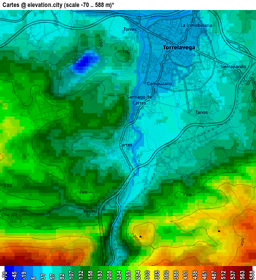
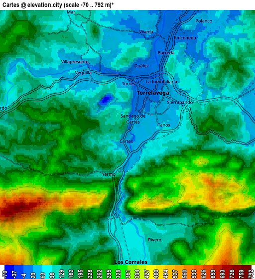
Below is the Elevation map of Cartes, which displays elevation range with different colors. Scale of the first map is from -70 to 588 m (-230 to 1929 ft) with average elevation of 149.3 meters (=490 ft) [note 1]
These maps also provides idea of topography and contour of this city, they are displayed at different zoom levels. More info about maps, scale and edge coordinates you can find below images.
| \ | Map #1 | Map #2 | Topo.Map |
| Scale [m] | -70..588 m | -70..792 m | × |
| Scale [ft] | -230..1929 ft | -230..2598 ft | × |
| Average | 149.3 m = 490 ft | 182.6 m = 599 ft | × |
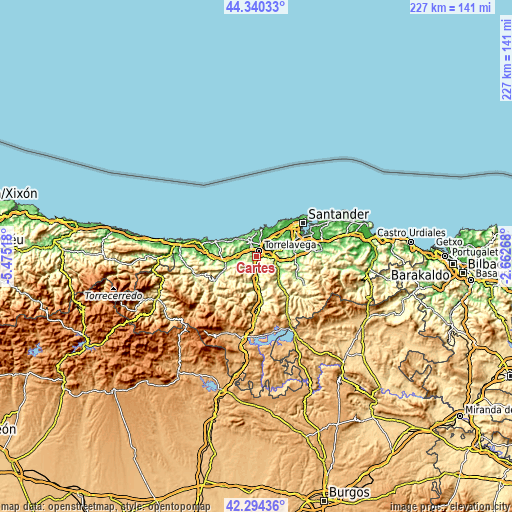
| Width | 7.11 km = 4.4 mi | 14.22 km = 8.8 mi | 227.5 km = 141.4 mi |
| Height | 7.11 km = 4.4 mi | 14.22 km = 8.8 mi | 227.5 km = 141.4 mi |
| ↑Max Latitude | 43.35792° | 43.389863° | 44.34033° |
| Latitude at center | 43.32596° | 43.32596° | 43.32596° |
| ↓Min Latitude | 43.293983° | 43.261989° | 42.29436° |
| ← Min Longitude | -4.112875° | -4.156821° | -5.47518° |
| Longitude center | -4.06893° | -4.06893° | -4.06893° |
| →Max Longitude | -4.024985° | -3.981039° | -2.66268° |
Nearby cities:
Cities around Cartes sort by population:
• Torrelavega elevation 31 m
3.1 km,  33°
33°
• Los Corrales de Buelna 92 m
6.9 km,  182°
182°
• Cabezón de la Sal 130 m
13.6 km,  261°
261°
• Reocín 105 m
2.5 km,  305°
305°
• Suances 7 m
12.1 km,  9°
9°
• Santillana 84 m
7.7 km,  335°
335°
• Miengo 25 m
12.7 km, 26°
• Puente Viesgo 83 m
8.7 km,  110°
110°
• Luzmela 141 m
11.8 km,  254°
254°
• Santiurde de Toranzo 126 m
14.3 km,  132°
132°
• Villafufre 222 m
15.7 km,  115°
115°
• Polanco 53 m
7.8 km, 32°
Multilingual:
 En español:
Cartes elevación 36 m.
 En France:
Cartes élévation 36 m.


Sources and notes:
- [note 1] Map square and city borders are not equal. Map elevation data is calculated only from area inside that square.
- [src 1] Elevation data from geonames database provided with same terms of usage.
- [src 2] The elevation map of Cartes is generated using elevation data from NASA's 3 arcsec (90m) resolution SRTM data.
- [src 3] Base (background) map © OpenStreetMap contributors tiles are generated by Geofabrik and OpenTopoMap.
Copyright & License:
This Cartes Elevation Map is licensed under CC BY-SA. You may reuse any part from this page, if you give a proper credit by linking to this URL:
 More info on terms of use page.