Puente Viesgo elevation
Puente Viesgo (Cantabria, Provincia de Cantabria), Spain elevation is 83 meters and Puente Viesgo elevation in feet is 272 ft above sea level [src 1]. Puente Viesgo is a seat of a third-order administrative division (feature code) with elevation that is 520 meters (1706 ft) smaller than average city elevation in Spain.
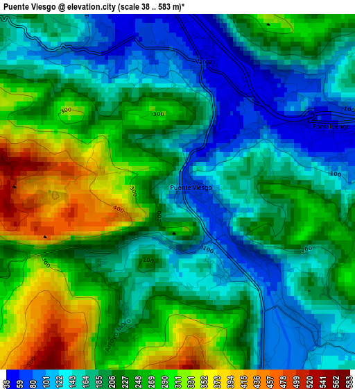
Below is the Elevation map of Puente Viesgo, which displays elevation range with different colors. Scale of the first map is from 38 to 583 m (125 to 1913 ft) with average elevation of 213 meters (=699 ft) [note 1]
These maps also provides idea of topography and contour of this city, they are displayed at different zoom levels. More info about maps, scale and edge coordinates you can find below images.
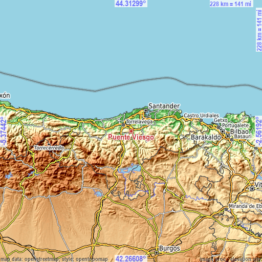
| \ | Map #1 | Topo.Map |
| Scale [m] | 38..583 m | × |
| Scale [ft] | 125..1913 ft | × |
| Average | 213 m = 699 ft | × |
| Width | 7.11 km = 4.4 mi | 227.6 km = 141.4 mi |
| Height | 7.11 km = 4.4 mi | 227.6 km = 141.4 mi |
| ↑Max Latitude | 43.330125° | 44.31299° |
| Latitude at center | 43.29815° | 43.29815° |
| ↓Min Latitude | 43.266158° | 42.26608° |
| ← Min Longitude | -4.012115° | -5.37442° |
| Longitude center | -3.96817° | -3.96817° |
| →Max Longitude | -3.924225° | -2.56192° |
Nearby cities:
Cities around Puente Viesgo sort by population:
• Torrelavega elevation 31 m
8.6 km,  311°
311°
• Camargo 32 m
13.9 km,  28°
28°
• Los Corrales de Buelna 92 m
9.3 km,  245°
245°
• Reocín 105 m
11.2 km,  294°
294°
• Santa María de Cayón 105 m
10.7 km,  83°
83°
• Cartes 36 m
8.7 km, 290°
• Arenas de Iguña 177 m
14.3 km,  206°
206°
• Penagos 134 m
13.9 km,  64°
64°
• Santiurde de Toranzo 126 m
7.1 km,  160°
160°
• Villafufre 222 m
7 km,  121°
121°
• Polanco 53 m
10.4 km,  338°
338°
• Saro 145 m
11 km,  112°
112°
Multilingual:
 En español:
Puente Viesgo elevación 83 m.
 En France:
Puente Viesgo élévation 83 m.
 Auf Deutsch:
Puente Viesgo höhe über dem Meeresspiegel ist 83 m.

Sources and notes:
- [note 1] Map square and city borders are not equal. Map elevation data is calculated only from area inside that square.
- [src 1] Elevation data from geonames database provided with same terms of usage.
- [src 2] The elevation map of Puente Viesgo is generated using elevation data from NASA's 3 arcsec (90m) resolution SRTM data.
- [src 3] Base (background) map © OpenStreetMap contributors tiles are generated by Geofabrik and OpenTopoMap.
Copyright & License:
This Puente Viesgo Elevation Map is licensed under CC BY-SA. You may reuse any part from this page, if you give a proper credit by linking to this URL:
 More info on terms of use page.