Castellote elevation
Castellote (Aragon, Provincia de Teruel), Spain elevation is 772 meters and Castellote elevation in feet is 2533 ft above sea level [src 1]. Castellote is a seat of a third-order administrative division (feature code) with elevation that is 169 meters (554 ft) bigger than average city elevation in Spain.
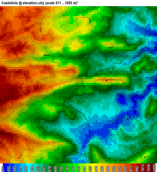
Below is the Elevation map of Castellote, which displays elevation range with different colors. Scale of the first map is from 511 to 1055 m (1677 to 3461 ft) with average elevation of 753 meters (=2470 ft) [note 1]
These maps also provides idea of topography and contour of this city, they are displayed at different zoom levels. More info about maps, scale and edge coordinates you can find below images.
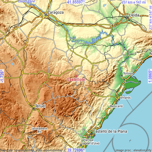
| \ | Map #1 | Topo.Map |
| Scale [m] | 511..1055 m | × |
| Scale [ft] | 1677..3461 ft | × |
| Average | 753 m = 2470 ft | × |
| Width | 7.4 km = 4.6 mi | 236.7 km = 147.1 mi |
| Height | 7.4 km = 4.6 mi | 236.7 km = 147.1 mi |
| ↑Max Latitude | 40.833258° | 41.85597° |
| Latitude at center | 40.8° | 40.8° |
| ↓Min Latitude | 40.766725° | 39.72696° |
| ← Min Longitude | -0.363695° | -1.726° |
| Longitude center | -0.31975° | -0.31975° |
| →Max Longitude | -0.275805° | 1.0865° |
Nearby cities:
Cities around Castellote sort by population:
• Calanda elevation 464 m
17.4 km,  25°
25°
• Alcorisa 631 m
11.5 km,  333°
333°
• Mas de las Matas 505 m
7.5 km,  59°
59°
• Aguaviva 540 m
10.8 km,  76°
76°
• Molinos 836 m
11.2 km,  282°
282°
• Foz-Calanda 502 m
14.3 km,  18°
18°
• Berge 727 m
11.1 km,  305°
305°
• Bordón 834 m
12.6 km,  180°
180°
• Zorita del Maestrazgo 656 m
15.2 km,  121°
121°
• Villores 727 m
17.2 km,  144°
144°
• Seno 811 m
2.1 km, 311°
• Palanques 692 m
14.9 km,  127°
127°
Multilingual:
 En español:
Castellote elevación 772 m.
 En France:
Castellote élévation 772 m.
 Auf Deutsch:
Castellote höhe über dem Meeresspiegel ist 772 m.

Sources and notes:
- [note 1] Map square and city borders are not equal. Map elevation data is calculated only from area inside that square.
- [src 1] Elevation data from geonames database provided with same terms of usage.
- [src 2] The elevation map of Castellote is generated using elevation data from NASA's 3 arcsec (90m) resolution SRTM data.
- [src 3] Base (background) map © OpenStreetMap contributors tiles are generated by Geofabrik and OpenTopoMap.
Copyright & License:
This Castellote Elevation Map is licensed under CC BY-SA. You may reuse any part from this page, if you give a proper credit by linking to this URL:
 More info on terms of use page.