Villores elevation
Villores (Valencia, Província de Castelló), Spain elevation is 727 meters and Villores elevation in feet is 2385 ft above sea level [src 1]. Villores is a seat of a third-order administrative division (feature code) with elevation that is 124 meters (407 ft) bigger than average city elevation in Spain.
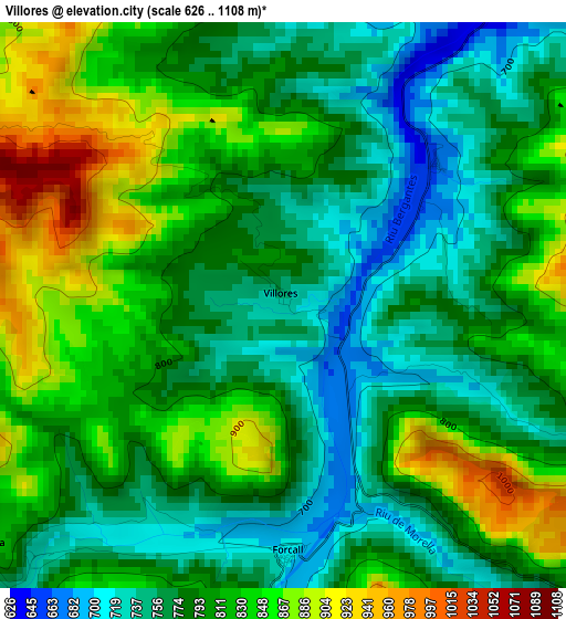
Below is the Elevation map of Villores, which displays elevation range with different colors. Scale of the first map is from 626 to 1108 m (2054 to 3635 ft) with average elevation of 801.1 meters (=2628 ft) [note 1]
These maps also provides idea of topography and contour of this city, they are displayed at different zoom levels. More info about maps, scale and edge coordinates you can find below images.
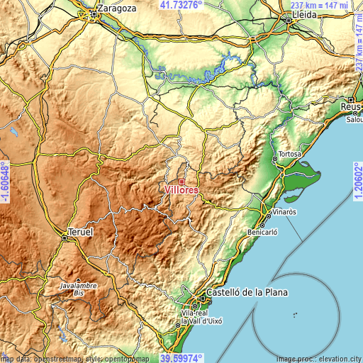
| \ | Map #1 | Topo.Map |
| Scale [m] | 626..1108 m | × |
| Scale [ft] | 2054..3635 ft | × |
| Average | 801.1 m = 2628 ft | × |
| Width | 7.41 km = 4.6 mi | 237.2 km = 147.4 mi |
| Height | 7.41 km = 4.6 mi | 237.2 km = 147.4 mi |
| ↑Max Latitude | 40.708101° | 41.73276° |
| Latitude at center | 40.67478° | 40.67478° |
| ↓Min Latitude | 40.641443° | 39.59974° |
| ← Min Longitude | -0.244175° | -1.60648° |
| Longitude center | -0.20023° | -0.20023° |
| →Max Longitude | -0.156285° | 1.20602° |
Nearby cities:
Cities around Villores sort by population:
• Morella elevation 972 m
10.5 km,  125°
125°
• Aguaviva 540 m
16.4 km,  1°
1°
• Forcall 715 m
3.3 km,  179°
179°
• Cinctorres 911 m
10.3 km,  187°
187°
• Portell de Morella 1079 m
16.7 km,  198°
198°
• Bordón 834 m
10.4 km,  277°
277°
• Todolella 801 m
5 km,  231°
231°
• Mirambel 922 m
15.5 km, 231°
• Olocau del Rey 1044 m
12.5 km,  250°
250°
• Zorita del Maestrazgo 656 m
6.6 km,  25°
25°
• Torre de Arcas 753 m
14 km,  52°
52°
• Palanques 692 m
5.1 km,  20°
20°
Multilingual:
 En español:
Villores elevación 727 m.
 En France:
Villores élévation 727 m.
 Auf Deutsch:
Villores höhe über dem Meeresspiegel ist 727 m.

Sources and notes:
- [note 1] Map square and city borders are not equal. Map elevation data is calculated only from area inside that square.
- [src 1] Elevation data from geonames database provided with same terms of usage.
- [src 2] The elevation map of Villores is generated using elevation data from NASA's 3 arcsec (90m) resolution SRTM data.
- [src 3] Base (background) map © OpenStreetMap contributors tiles are generated by Geofabrik and OpenTopoMap.
Copyright & License:
This Villores Elevation Map is licensed under CC BY-SA. You may reuse any part from this page, if you give a proper credit by linking to this URL:
 More info on terms of use page.