Morella elevation
Morella (Valencia, Província de Castelló), Spain elevation is 972 meters and Morella elevation in feet is 3189 ft above sea level [src 1]. Morella is a seat of a third-order administrative division (feature code) with elevation that is 369 meters (1211 ft) bigger than average city elevation in Spain.
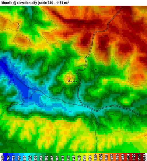
Below is the Elevation map of Morella, which displays elevation range with different colors. Scale of the first map is from 744 to 1151 m (2441 to 3776 ft) with average elevation of 949.1 meters (=3114 ft) [note 1]
These maps also provides idea of topography and contour of this city, they are displayed at different zoom levels. More info about maps, scale and edge coordinates you can find below images.
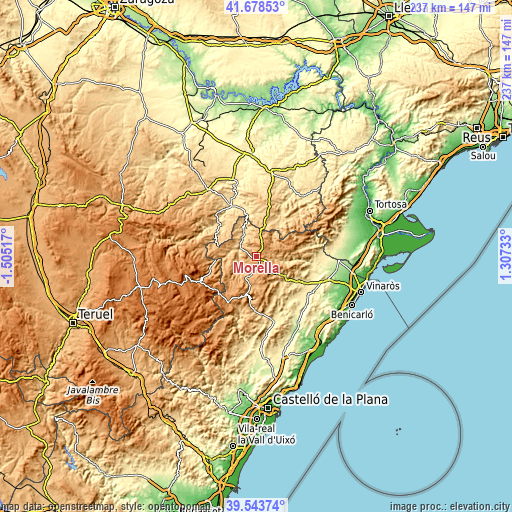
| \ | Map #1 | Topo.Map |
| Scale [m] | 744..1151 m | × |
| Scale [ft] | 2441..3776 ft | × |
| Average | 949.1 m = 3114 ft | × |
| Width | 7.42 km = 4.6 mi | 237.4 km = 147.5 mi |
| Height | 7.42 km = 4.6 mi | 237.4 km = 147.5 mi |
| ↑Max Latitude | 40.653008° | 41.67853° |
| Latitude at center | 40.61966° | 40.61966° |
| ↓Min Latitude | 40.586295° | 39.54374° |
| ← Min Longitude | -0.142865° | -1.50517° |
| Longitude center | -0.09892° | -0.09892° |
| →Max Longitude | -0.054975° | 1.30733° |
Nearby cities:
Cities around Morella sort by population:
• Forcall elevation 715 m
9 km,  288°
288°
• Cinctorres 911 m
10.7 km,  247°
247°
• Portell de Morella 1079 m
16.9 km,  235°
235°
• Castellfort 1156 m
15.2 km,  210°
210°
• Todolella 801 m
12.8 km,  283°
283°
• Zorita del Maestrazgo 656 m
13.3 km,  334°
334°
• Torre de Arcas 753 m
14.9 km,  9°
9°
• Vallibona 668 m
12.4 km,  98°
98°
• Herbés 782 m
13.8 km,  35°
35°
• Villores 727 m
10.5 km,  305°
305°
• Palanques 692 m
12.9 km, 328°
• Castell de Cabres 1139 m
12.7 km,  69°
69°
Multilingual:
 En español:
Morella elevación 972 m.
 En France:
Morella élévation 972 m.


Sources and notes:
- [note 1] Map square and city borders are not equal. Map elevation data is calculated only from area inside that square.
- [src 1] Elevation data from geonames database provided with same terms of usage.
- [src 2] The elevation map of Morella is generated using elevation data from NASA's 3 arcsec (90m) resolution SRTM data.
- [src 3] Base (background) map © OpenStreetMap contributors tiles are generated by Geofabrik and OpenTopoMap.
Copyright & License:
This Morella Elevation Map is licensed under CC BY-SA. You may reuse any part from this page, if you give a proper credit by linking to this URL:
 More info on terms of use page.