Castelserás elevation
Castelserás (Aragon, Provincia de Teruel), Spain elevation is 370 meters and Castelserás elevation in feet is 1214 ft above sea level [src 1]. Castelserás is a seat of a third-order administrative division (feature code) with elevation that is 233 meters (764 ft) smaller than average city elevation in Spain.
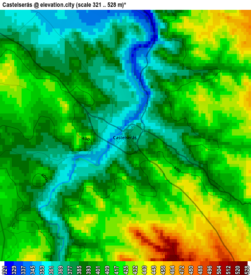
Below is the Elevation map of Castelserás, which displays elevation range with different colors. Scale of the first map is from 321 to 528 m (1053 to 1732 ft) with average elevation of 402.8 meters (=1322 ft) [note 1]
These maps also provides idea of topography and contour of this city, they are displayed at different zoom levels. More info about maps, scale and edge coordinates you can find below images.
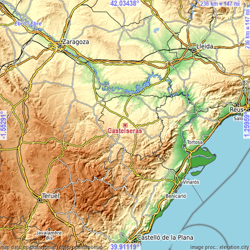
| \ | Map #1 | Topo.Map |
| Scale [m] | 321..528 m | × |
| Scale [ft] | 1053..1732 ft | × |
| Average | 402.8 m = 1322 ft | × |
| Width | 7.38 km = 4.6 mi | 236.1 km = 146.7 mi |
| Height | 7.38 km = 4.6 mi | 236.1 km = 146.7 mi |
| ↑Max Latitude | 41.014497° | 42.03438° |
| Latitude at center | 40.98133° | 40.98133° |
| ↓Min Latitude | 40.948146° | 39.91119° |
| ← Min Longitude | -0.190605° | -1.55291° |
| Longitude center | -0.14666° | -0.14666° |
| →Max Longitude | -0.102715° | 1.25959° |
Nearby cities:
Cities around Castelserás sort by population:
• Alcañiz elevation 346 m
7.7 km,  8°
8°
• Calanda 464 m
8.5 km,  238°
238°
• Mas de las Matas 505 m
18.3 km,  206°
206°
• Valdealgorfa 510 m
9.5 km,  83°
83°
• Aguaviva 540 m
18.2 km,  193°
193°
• Torrecilla de Alcañiz 451 m
5.2 km,  116°
116°
• Valjunquera 553 m
14.8 km,  102°
102°
• Valdeltormo 448 m
19.3 km,  88°
88°
• Foz-Calanda 502 m
11.9 km, 236°
• La Ginebrosa 715 m
12.4 km,  175°
175°
• Torrevelilla 624 m
9.3 km,  160°
160°
• Fórnoles 716 m
15.5 km,  129°
129°
Multilingual:
 En español:
Castelserás elevación 370 m.
 En France:
Castelserás élévation 370 m.
 Auf Deutsch:
Castelserás höhe über dem Meeresspiegel ist 370 m.

Sources and notes:
- [note 1] Map square and city borders are not equal. Map elevation data is calculated only from area inside that square.
- [src 1] Elevation data from geonames database provided with same terms of usage.
- [src 2] The elevation map of Castelserás is generated using elevation data from NASA's 3 arcsec (90m) resolution SRTM data.
- [src 3] Base (background) map © OpenStreetMap contributors tiles are generated by Geofabrik and OpenTopoMap.
Copyright & License:
This Castelserás Elevation Map is licensed under CC BY-SA. You may reuse any part from this page, if you give a proper credit by linking to this URL:
 More info on terms of use page.