Fórnoles elevation
Fórnoles (Aragon, Provincia de Teruel), Spain elevation is 716 meters and Fórnoles elevation in feet is 2349 ft above sea level [src 1]. Fórnoles is a seat of a third-order administrative division (feature code) with elevation that is 113 meters (371 ft) bigger than average city elevation in Spain.
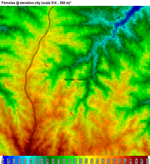
Below is the Elevation map of Fórnoles, which displays elevation range with different colors. Scale of the first map is from 514 to 850 m (1686 to 2789 ft) with average elevation of 696.3 meters (=2284 ft) [note 1]
These maps also provides idea of topography and contour of this city, they are displayed at different zoom levels. More info about maps, scale and edge coordinates you can find below images.
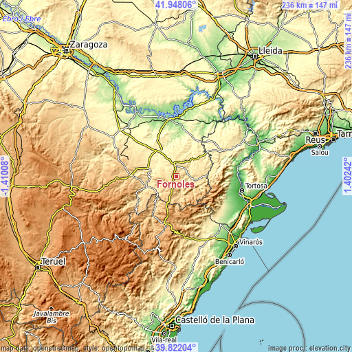
| \ | Map #1 | Topo.Map |
| Scale [m] | 514..850 m | × |
| Scale [ft] | 1686..2789 ft | × |
| Average | 696.3 m = 2284 ft | × |
| Width | 7.39 km = 4.6 mi | 236.4 km = 146.9 mi |
| Height | 7.39 km = 4.6 mi | 236.4 km = 146.9 mi |
| ↑Max Latitude | 40.926801° | 41.94806° |
| Latitude at center | 40.89359° | 40.89359° |
| ↓Min Latitude | 40.860362° | 39.82204° |
| ← Min Longitude | -0.047775° | -1.41008° |
| Longitude center | -0.00383° | -0.00383° |
| →Max Longitude | 0.040115° | 1.40242° |
Nearby cities:
Cities around Fórnoles sort by population:
• Valderrobres elevation 498 m
13.5 km,  100°
100°
• Castelserás 370 m
15.5 km,  309°
309°
• Valdealgorfa 510 m
11.1 km,  346°
346°
• Torrecilla de Alcañiz 451 m
10.4 km,  315°
315°
• Valjunquera 553 m
7 km,  20°
20°
• Fuentespalda 718 m
11.3 km,  149°
149°
• Valdeltormo 448 m
12.7 km,  35°
35°
• Monroyo 876 m
12.1 km,  192°
192°
• La Ginebrosa 715 m
11.4 km,  256°
256°
• Torrevelilla 624 m
9 km,  275°
275°
• Ráfales 634 m
6.5 km,  162°
162°
• Torre del Compte 505 m
10.6 km,  63°
63°
Multilingual:
 En español:
Fórnoles elevación 716 m.
 En France:
Fórnoles élévation 716 m.
 Auf Deutsch:
Fórnoles höhe über dem Meeresspiegel ist 716 m.

Sources and notes:
- [note 1] Map square and city borders are not equal. Map elevation data is calculated only from area inside that square.
- [src 1] Elevation data from geonames database provided with same terms of usage.
- [src 2] The elevation map of Fórnoles is generated using elevation data from NASA's 3 arcsec (90m) resolution SRTM data.
- [src 3] Base (background) map © OpenStreetMap contributors tiles are generated by Geofabrik and OpenTopoMap.
Copyright & License:
This Fórnoles Elevation Map is licensed under CC BY-SA. You may reuse any part from this page, if you give a proper credit by linking to this URL:
 More info on terms of use page.