Castroverde elevation
Castroverde (Galicia, Provincia de Lugo), Spain elevation is 580 meters and Castroverde elevation in feet is 1903 ft above sea level [src 1]. Castroverde is a seat of a third-order administrative division (feature code) with elevation that is 23 meters (75 ft) smaller than average city elevation in Spain.
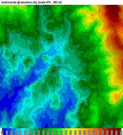
Below is the Elevation map of Castroverde, which displays elevation range with different colors. Scale of the first map is from 470 to 983 m (1542 to 3225 ft) with average elevation of 634.2 meters (=2081 ft) [note 1]
These maps also provides idea of topography and contour of this city, they are displayed at different zoom levels. More info about maps, scale and edge coordinates you can find below images.
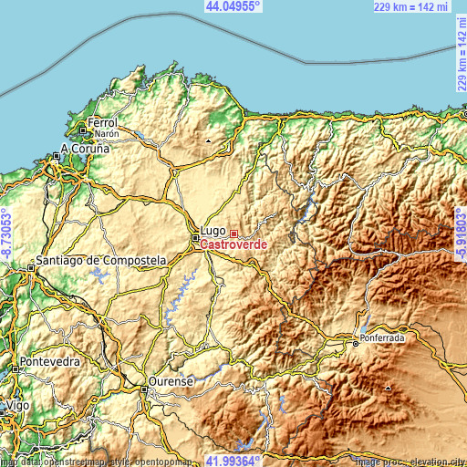
| \ | Map #1 | Topo.Map |
| Scale [m] | 470..983 m | × |
| Scale [ft] | 1542..3225 ft | × |
| Average | 634.2 m = 2081 ft | × |
| Width | 7.14 km = 4.4 mi | 228.6 km = 142 mi |
| Height | 7.14 km = 4.4 mi | 228.6 km = 142 mi |
| ↑Max Latitude | 43.062315° | 44.04955° |
| Latitude at center | 43.0302° | 43.0302° |
| ↓Min Latitude | 42.998068° | 41.99364° |
| ← Min Longitude | -7.368225° | -8.73053° |
| Longitude center | -7.32428° | -7.32428° |
| →Max Longitude | -7.280335° | -5.91803° |
Nearby cities:
Cities around Castroverde sort by population:
• Lugo elevation 465 m
19 km,  263°
263°
• Mos 400 m
23.1 km,  307°
307°
• Castro de Rei 435 m
20.8 km,  342°
342°
• Fonsagrada 962 m
23.3 km,  63°
63°
• Outeiro 553 m
13 km,  11°
11°
• Corgo 441 m
12.9 km,  222°
222°
• Becerreá 634 m
23.4 km,  145°
145°
• Baralla 484 m
16.4 km,  159°
159°
• Láncara 452 m
18.5 km,  183°
183°
• O Páramo 704 m
9.1 km,  167°
167°
• Meira 483 m
20.5 km, 6°
• Pol 506 m
13.2 km,  357°
357°
Multilingual:
 En español:
Castroverde elevación 580 m.
 En France:
Castroverde élévation 580 m.
 Auf Deutsch:
Castroverde höhe über dem Meeresspiegel ist 580 m.

Sources and notes:
- [note 1] Map square and city borders are not equal. Map elevation data is calculated only from area inside that square.
- [src 1] Elevation data from geonames database provided with same terms of usage.
- [src 2] The elevation map of Castroverde is generated using elevation data from NASA's 3 arcsec (90m) resolution SRTM data.
- [src 3] Base (background) map © OpenStreetMap contributors tiles are generated by Geofabrik and OpenTopoMap.
Copyright & License:
This Castroverde Elevation Map is licensed under CC BY-SA. You may reuse any part from this page, if you give a proper credit by linking to this URL:
 More info on terms of use page.