Cella elevation
Cella (Aragon, Provincia de Teruel), Spain elevation is 1043 meters and Cella elevation in feet is 3422 ft above sea level [src 1]. Cella is a seat of a third-order administrative division (feature code) with elevation that is 440 meters (1444 ft) bigger than average city elevation in Spain.
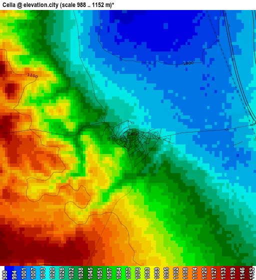
Below is the Elevation map of Cella, which displays elevation range with different colors. Scale of the first map is from 988 to 1152 m (3241 to 3780 ft) with average elevation of 1051.3 meters (=3449 ft) [note 1]
These maps also provides idea of topography and contour of this city, they are displayed at different zoom levels. More info about maps, scale and edge coordinates you can find below images.
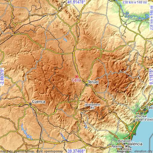
| \ | Map #1 | Topo.Map |
| Scale [m] | 988..1152 m | × |
| Scale [ft] | 3241..3780 ft | × |
| Average | 1051.3 m = 3449 ft | × |
| Width | 7.44 km = 4.6 mi | 238 km = 147.9 mi |
| Height | 7.44 km = 4.6 mi | 238 km = 147.9 mi |
| ↑Max Latitude | 40.486681° | 41.51478° |
| Latitude at center | 40.45325° | 40.45325° |
| ↓Min Latitude | 40.419802° | 39.37468° |
| ← Min Longitude | -1.331445° | -2.69375° |
| Longitude center | -1.2875° | -1.2875° |
| →Max Longitude | -1.243555° | 0.11875° |
Nearby cities:
Cities around Cella sort by population:
• Teruel elevation 908 m
19.4 km,  127°
127°
• Santa Eulalia 989 m
12.9 km,  350°
350°
• Albarracín 1172 m
14.1 km,  249°
249°
• Villarquemado 1001 m
7.4 km,  14°
14°
• Gea de Albarracín 1038 m
7 km,  227°
227°
• Alba 982 m
19 km,  344°
344°
• Cuevas Labradas 969 m
20.1 km,  89°
89°
• Pozondón 1408 m
19.6 km,  307°
307°
• Bezas 1166 m
14 km,  193°
193°
• Rubiales 1161 m
19.7 km,  176°
176°
• Monterde de Albarracín 1286 m
18 km,  285°
285°
• Saldón 1395 m
18.6 km,  219°
219°
Multilingual:
 En español:
Cella elevación 1043 m.
 En France:
Cella élévation 1043 m.


Sources and notes:
- [note 1] Map square and city borders are not equal. Map elevation data is calculated only from area inside that square.
- [src 1] Elevation data from geonames database provided with same terms of usage.
- [src 2] The elevation map of Cella is generated using elevation data from NASA's 3 arcsec (90m) resolution SRTM data.
- [src 3] Base (background) map © OpenStreetMap contributors tiles are generated by Geofabrik and OpenTopoMap.
Copyright & License:
This Cella Elevation Map is licensed under CC BY-SA. You may reuse any part from this page, if you give a proper credit by linking to this URL:
 More info on terms of use page.