Teruel elevation
Teruel (Aragon, Provincia de Teruel), Spain elevation is 908 meters and Teruel elevation in feet is 2979 ft above sea level [src 1]. Teruel is a seat of a second-order administrative division (feature code) with elevation that is 305 meters (1001 ft) bigger than average city elevation in Spain.
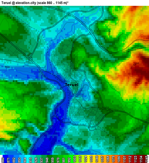
Below is the Elevation map of Teruel, which displays elevation range with different colors. Scale of the first map is from 860 to 1145 m (2822 to 3757 ft) with average elevation of 951.2 meters (=3121 ft) [note 1]
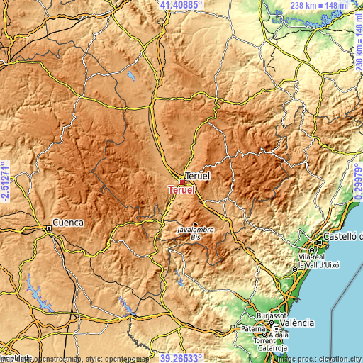
These maps also provides idea of topography and contour of this city, they are displayed at different zoom levels. More info about maps, scale and edge coordinates you can find below images.
| \ | Map #1 | Map #2 | Topo.Map |
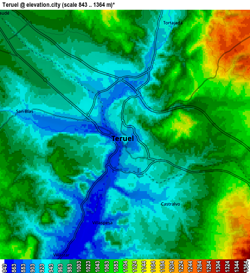
| Scale [m] | 860..1145 m | 843..1364 m | × |
| Scale [ft] | 2822..3757 ft | 2766..4475 ft | × |
| Average | 951.2 m = 3121 ft | 999.7 m = 3280 ft | × |
| Width | 7.45 km = 4.6 mi | 14.9 km = 9.3 mi | 238.3 km = 148.1 mi |
| Height | 7.45 km = 4.6 mi | 14.9 km = 9.3 mi | 238.3 km = 148.1 mi |
| ↑Max Latitude | 40.379085° | 40.412553° | 41.40885° |
| Latitude at center | 40.3456° | 40.3456° | 40.3456° |
| ↓Min Latitude | 40.312099° | 40.278581° | 39.26533° |
| ← Min Longitude | -1.150405° | -1.194351° | -2.51271° |
| Longitude center | -1.10646° | -1.10646° | -1.10646° |
| →Max Longitude | -1.062515° | -1.018569° | 0.29979° |
Nearby cities:
Cities around Teruel sort by population:
• Cella elevation 1043 m
19.4 km,  307°
307°
• Villastar 861 m
8.1 km,  207°
207°
• Villel 824 m
14.1 km, 208°
• Formiche Alto 1089 m
18.3 km,  97°
97°
• Cuevas Labradas 969 m
12.9 km,  21°
21°
• Cascante del Río 997 m
16.6 km,  182°
182°
• Peralejos 1012 m
16.6 km, 21°
• Corbalán 1267 m
12.1 km,  58°
58°
• Bezas 1166 m
18.6 km,  264°
264°
• Rubiales 1161 m
16 km,  241°
241°
• Cubla 1094 m
15.3 km,  171°
171°
• Valacloche 988 m
17.2 km, 175°
Multilingual:
 En español:
Teruel elevación 908 m.
 En France:
Teruel élévation 908 m.


Sources and notes:
- [note 1] Map square and city borders are not equal. Map elevation data is calculated only from area inside that square.
- [src 1] Elevation data from geonames database provided with same terms of usage.
- [src 2] The elevation map of Teruel is generated using elevation data from NASA's 3 arcsec (90m) resolution SRTM data.
- [src 3] Base (background) map © OpenStreetMap contributors tiles are generated by Geofabrik and OpenTopoMap.
Copyright & License:
This Teruel Elevation Map is licensed under CC BY-SA. You may reuse any part from this page, if you give a proper credit by linking to this URL:
 More info on terms of use page.