Pozondón elevation
Pozondón (Aragon, Provincia de Teruel), Spain elevation is 1408 meters and Pozondón elevation in feet is 4619 ft above sea level [src 1]. Pozondón is a seat of a third-order administrative division (feature code) with elevation that is 805 meters (2641 ft) bigger than average city elevation in Spain.
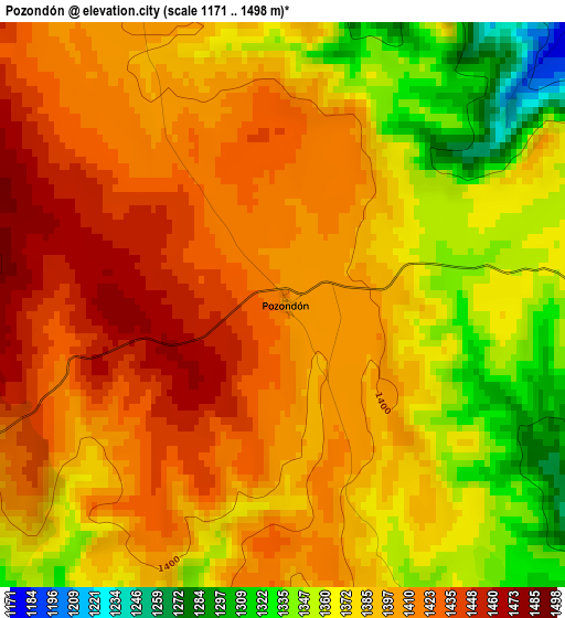
Below is the Elevation map of Pozondón, which displays elevation range with different colors. Scale of the first map is from 1171 to 1498 m (3842 to 4915 ft) with average elevation of 1390.8 meters (=4563 ft) [note 1]
These maps also provides idea of topography and contour of this city, they are displayed at different zoom levels. More info about maps, scale and edge coordinates you can find below images.
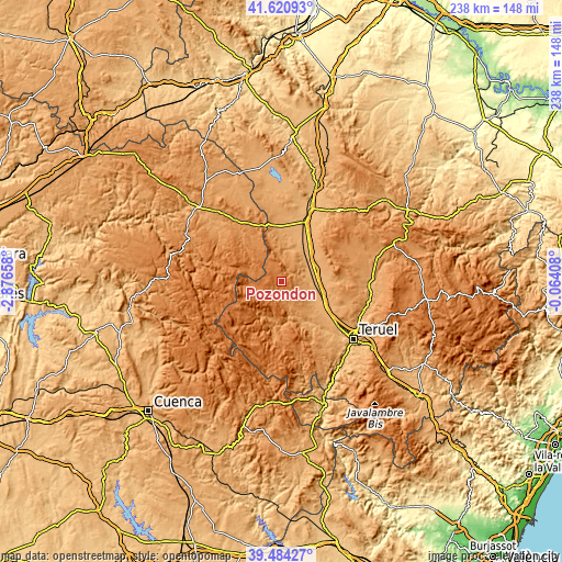
| \ | Map #1 | Topo.Map |
| Scale [m] | 1171..1498 m | × |
| Scale [ft] | 3842..4915 ft | × |
| Average | 1390.8 m = 4563 ft | × |
| Width | 7.42 km = 4.6 mi | 237.6 km = 147.6 mi |
| Height | 7.42 km = 4.6 mi | 237.6 km = 147.6 mi |
| ↑Max Latitude | 40.594497° | 41.62093° |
| Latitude at center | 40.56112° | 40.56112° |
| ↓Min Latitude | 40.527726° | 39.48427° |
| ← Min Longitude | -1.514275° | -2.87658° |
| Longitude center | -1.47033° | -1.47033° |
| →Max Longitude | -1.426385° | -0.06408° |
Nearby cities:
Cities around Pozondón sort by population:
• Santa Eulalia elevation 989 m
13.3 km,  86°
86°
• Orihuela del Tremedal 1439 m
15.2 km,  265°
265°
• Bronchales 1582 m
11.4 km,  241°
241°
• Alba 982 m
12.2 km,  58°
58°
• Tordesilos 1350 m
16 km,  319°
319°
• Torres de Albarracín 1235 m
15.8 km,  199°
199°
• Peracense 1226 m
8.9 km,  359°
359°
• Villar del Salz 1215 m
13.7 km,  349°
349°
• Singra 1031 m
17 km,  52°
52°
• Ródenas 1370 m
9.7 km,  336°
336°
• Monterde de Albarracín 1286 m
7.4 km,  194°
194°
• Almohaja 1198 m
5.6 km,  29°
29°
Multilingual:
 En español:
Pozondón elevación 1408 m.
 En France:
Pozondón élévation 1408 m.
 Auf Deutsch:
Pozondón höhe über dem Meeresspiegel ist 1408 m.

Sources and notes:
- [note 1] Map square and city borders are not equal. Map elevation data is calculated only from area inside that square.
- [src 1] Elevation data from geonames database provided with same terms of usage.
- [src 2] The elevation map of Pozondón is generated using elevation data from NASA's 3 arcsec (90m) resolution SRTM data.
- [src 3] Base (background) map © OpenStreetMap contributors tiles are generated by Geofabrik and OpenTopoMap.
Copyright & License:
This Pozondón Elevation Map is licensed under CC BY-SA. You may reuse any part from this page, if you give a proper credit by linking to this URL:
 More info on terms of use page.