Bronchales elevation
Bronchales (Aragon, Provincia de Teruel), Spain elevation is 1582 meters and Bronchales elevation in feet is 5190 ft above sea level [src 1]. Bronchales is a seat of a third-order administrative division (feature code) with elevation that is 979 meters (3212 ft) bigger than average city elevation in Spain.
Below is the Elevation map of Bronchales, which displays elevation range with different colors. Scale of the first map is from 1406 to 1848 m (4613 to 6063 ft) with average elevation of 1582.6 meters (=5192 ft) [note 1]
These maps also provides idea of topography and contour of this city, they are displayed at different zoom levels. More info about maps, scale and edge coordinates you can find below images.
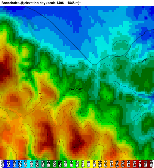
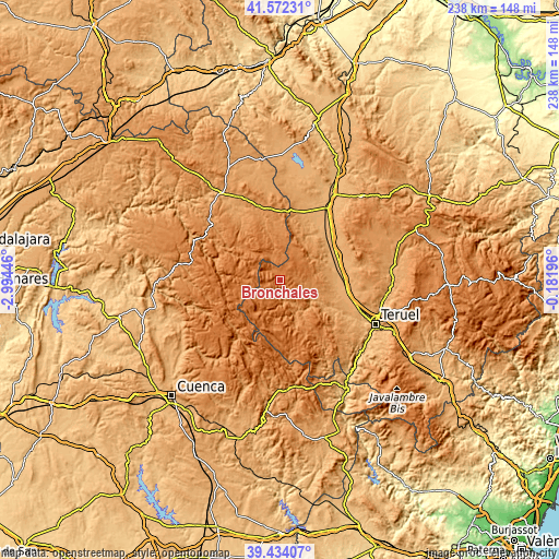
| \ | Map #1 | Topo.Map |
| Scale [m] | 1406..1848 m | × |
| Scale [ft] | 4613..6063 ft | × |
| Average | 1582.6 m = 5192 ft | × |
| Width | 7.43 km = 4.6 mi | 237.8 km = 147.8 mi |
| Height | 7.43 km = 4.6 mi | 237.7 km = 147.7 mi |
| ↑Max Latitude | 40.545112° | 41.57231° |
| Latitude at center | 40.51171° | 40.51171° |
| ↓Min Latitude | 40.478291° | 39.43407° |
| ← Min Longitude | -1.632155° | -2.99446° |
| Longitude center | -1.58821° | -1.58821° |
| →Max Longitude | -1.544265° | -0.18196° |
Nearby cities:
Cities around Bronchales sort by population:
• Orihuela del Tremedal elevation 1439 m
6.7 km,  309°
309°
• Alustante 1404 m
12.9 km,  332°
332°
• Orea 1502 m
12.8 km,  293°
293°
• Villar del Cobo 1433 m
14.9 km,  208°
208°
• Royuela 1207 m
16.1 km,  156°
156°
• Torres de Albarracín 1235 m
10.5 km,  153°
153°
• Griegos 1610 m
14.1 km,  228°
228°
• Tramacastilla 1269 m
9.1 km,  172°
172°
• Pozondón 1408 m
11.4 km,  61°
61°
• Ródenas 1370 m
15.6 km,  22°
22°
• Calomarde 1320 m
15.5 km,  175°
175°
• Monterde de Albarracín 1286 m
8.3 km,  101°
101°
Multilingual:
 En español:
Bronchales elevación 1582 m.
 En France:
Bronchales élévation 1582 m.
 Auf Deutsch:
Bronchales höhe über dem Meeresspiegel ist 1582 m.

Sources and notes:
- [note 1] Map square and city borders are not equal. Map elevation data is calculated only from area inside that square.
- [src 1] Elevation data from geonames database provided with same terms of usage.
- [src 2] The elevation map of Bronchales is generated using elevation data from NASA's 3 arcsec (90m) resolution SRTM data.
- [src 3] Base (background) map © OpenStreetMap contributors tiles are generated by Geofabrik and OpenTopoMap.
Copyright & License:
This Bronchales Elevation Map is licensed under CC BY-SA. You may reuse any part from this page, if you give a proper credit by linking to this URL:
 More info on terms of use page.