Elciego elevation
Elciego (Basque Country, Araba / Álava), Spain elevation is 463 meters and Elciego elevation in feet is 1519 ft above sea level [src 1]. Elciego is a seat of a third-order administrative division (feature code) with elevation that is 140 meters (459 ft) smaller than average city elevation in Spain.
Below is the Elevation map of Elciego, which displays elevation range with different colors. Scale of the first map is from 389 to 570 m (1276 to 1870 ft) with average elevation of 475.7 meters (=1561 ft) [note 1]
These maps also provides idea of topography and contour of this city, they are displayed at different zoom levels. More info about maps, scale and edge coordinates you can find below images.
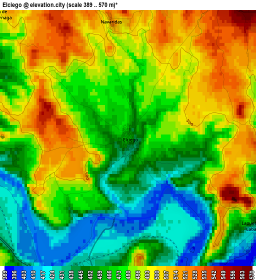
| \ | Map #1 | Topo.Map |
| Scale [m] | 389..570 m | × |
| Scale [ft] | 1276..1870 ft | × |
| Average | 475.7 m = 1561 ft | × |
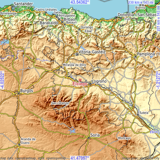
| Width | 7.2 km = 4.5 mi | 230.5 km = 143.2 mi |
| Height | 7.2 km = 4.5 mi | 230.5 km = 143.2 mi |
| ↑Max Latitude | 42.548073° | 43.54362° |
| Latitude at center | 42.51569° | 42.51569° |
| ↓Min Latitude | 42.48329° | 41.47057° |
| ← Min Longitude | -2.662915° | -4.02522° |
| Longitude center | -2.61897° | -2.61897° |
| →Max Longitude | -2.575025° | -1.21272° |
Nearby cities:
Cities around Elciego sort by population:
• Fuenmayor elevation 435 m
7.2 km,  138°
138°
• Cenicero 439 m
4.3 km,  208°
208°
• Laguardia 639 m
5.1 km,  32°
32°
• Lapuebla de Labarca 434 m
4.4 km,  122°
122°
• Uruñuela 499 m
10.9 km,  221°
221°
• Samaniego 572 m
7.7 km,  319°
319°
• Eskuernaga / Villabuena de Álava 487 m
5.2 km,  313°
313°
• Ábalos 590 m
9.7 km, 309°
• Leza 574 m
5.7 km,  348°
348°
• Navaridas 501 m
3.4 km, 349°
• Torremontalbo 419 m
5.6 km,  251°
251°
• Navarrete 502 m
10.4 km,  154°
154°
Multilingual:
 En español:
Elciego elevación 463 m.
 En France:
Elciego élévation 463 m.


Sources and notes:
- [note 1] Map square and city borders are not equal. Map elevation data is calculated only from area inside that square.
- [src 1] Elevation data from geonames database provided with same terms of usage.
- [src 2] The elevation map of Elciego is generated using elevation data from NASA's 3 arcsec (90m) resolution SRTM data.
- [src 3] Base (background) map © OpenStreetMap contributors tiles are generated by Geofabrik and OpenTopoMap.
Copyright & License:
This Elciego Elevation Map is licensed under CC BY-SA. You may reuse any part from this page, if you give a proper credit by linking to this URL:
 More info on terms of use page.