Samaniego elevation
Samaniego (Basque Country, Araba / Álava), Spain elevation is 572 meters and Samaniego elevation in feet is 1877 ft above sea level [src 1]. Samaniego is a seat of a third-order administrative division (feature code) with elevation that is 31 meters (102 ft) smaller than average city elevation in Spain.
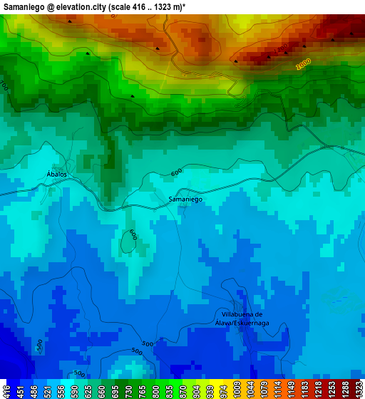
Below is the Elevation map of Samaniego, which displays elevation range with different colors. Scale of the first map is from 416 to 1323 m (1365 to 4341 ft) with average elevation of 658.1 meters (=2159 ft) [note 1]
These maps also provides idea of topography and contour of this city, they are displayed at different zoom levels. More info about maps, scale and edge coordinates you can find below images.
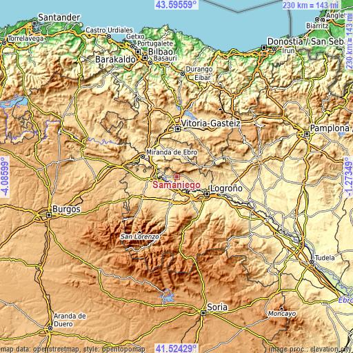
| \ | Map #1 | Topo.Map |
| Scale [m] | 416..1323 m | × |
| Scale [ft] | 1365..4341 ft | × |
| Average | 658.1 m = 2159 ft | × |
| Width | 7.2 km = 4.5 mi | 230.3 km = 143.1 mi |
| Height | 7.2 km = 4.5 mi | 230.3 km = 143.1 mi |
| ↑Max Latitude | 42.600896° | 43.59559° |
| Latitude at center | 42.56854° | 42.56854° |
| ↓Min Latitude | 42.536167° | 41.52429° |
| ← Min Longitude | -2.723685° | -4.08599° |
| Longitude center | -2.67974° | -2.67974° |
| →Max Longitude | -2.635795° | -1.27349° |
Nearby cities:
Cities around Samaniego sort by population:
• Laguardia elevation 639 m
7.9 km,  101°
101°
• Bastida / Labastida 532 m
9.8 km,  283°
283°
• San Asensio 530 m
9.9 km,  216°
216°
• San Vicente de la Sonsierra 489 m
6.7 km,  264°
264°
• Elciego 463 m
7.7 km,  139°
139°
• Briones 505 m
9.1 km,  252°
252°
• Eskuernaga / Villabuena de Álava 487 m
2.6 km,  153°
153°
• Ábalos 590 m
2.5 km, 277°
• Leza 574 m
3.8 km, 95°
• Navaridas 501 m
5 km,  120°
120°
• Lagrán 751 m
10.1 km,  50°
50°
• Torremontalbo 419 m
7.6 km,  182°
182°
Multilingual:
 En español:
Samaniego elevación 572 m.
 En France:
Samaniego élévation 572 m.
 Auf Deutsch:
Samaniego höhe über dem Meeresspiegel ist 572 m.

Sources and notes:
- [note 1] Map square and city borders are not equal. Map elevation data is calculated only from area inside that square.
- [src 1] Elevation data from geonames database provided with same terms of usage.
- [src 2] The elevation map of Samaniego is generated using elevation data from NASA's 3 arcsec (90m) resolution SRTM data.
- [src 3] Base (background) map © OpenStreetMap contributors tiles are generated by Geofabrik and OpenTopoMap.
Copyright & License:
This Samaniego Elevation Map is licensed under CC BY-SA. You may reuse any part from this page, if you give a proper credit by linking to this URL:
 More info on terms of use page.