Fuenmayor elevation
Fuenmayor (La Rioja, Provincia de La Rioja), Spain elevation is 435 meters and Fuenmayor elevation in feet is 1427 ft above sea level [src 1]. Fuenmayor is a seat of a third-order administrative division (feature code) with elevation that is 168 meters (551 ft) smaller than average city elevation in Spain.
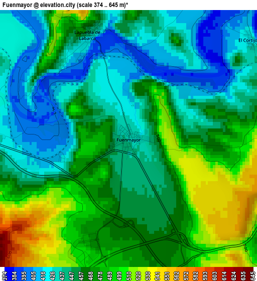
Below is the Elevation map of Fuenmayor, which displays elevation range with different colors. Scale of the first map is from 374 to 645 m (1227 to 2116 ft) with average elevation of 460.5 meters (=1511 ft) [note 1]
These maps also provides idea of topography and contour of this city, they are displayed at different zoom levels. More info about maps, scale and edge coordinates you can find below images.
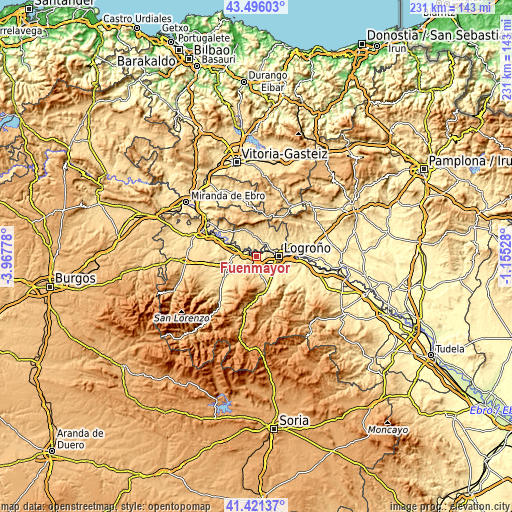
| \ | Map #1 | Topo.Map |
| Scale [m] | 374..645 m | × |
| Scale [ft] | 1227..2116 ft | × |
| Average | 460.5 m = 1511 ft | × |
| Width | 7.21 km = 4.5 mi | 230.7 km = 143.4 mi |
| Height | 7.21 km = 4.5 mi | 230.7 km = 143.4 mi |
| ↑Max Latitude | 42.499698° | 43.49603° |
| Latitude at center | 42.46729° | 42.46729° |
| ↓Min Latitude | 42.434865° | 41.42137° |
| ← Min Longitude | -2.605475° | -3.96778° |
| Longitude center | -2.56153° | -2.56153° |
| →Max Longitude | -2.517585° | -1.15528° |
Nearby cities:
Cities around Fuenmayor sort by population:
• Logroño elevation 389 m
9.1 km,  90°
90°
• Lardero 438 m
9.4 km,  118°
118°
• Cenicero 439 m
7 km,  282°
282°
• Laguardia 639 m
9.9 km,  348°
348°
• Entrena 554 m
9.2 km,  164°
164°
• Elciego 463 m
7.2 km,  318°
318°
• Lapuebla de Labarca 434 m
3.2 km,  342°
342°
• Navaridas 501 m
10.2 km,  328°
328°
• Medrano 597 m
9.3 km,  176°
176°
• Ventosa 647 m
8.7 km,  217°
217°
• Hornos de Moncalvillo 677 m
8.6 km,  193°
193°
• Navarrete 502 m
4.1 km, 183°
Multilingual:
 En español:
Fuenmayor elevación 435 m.
 En France:
Fuenmayor élévation 435 m.
 Auf Deutsch:
Fuenmayor höhe über dem Meeresspiegel ist 435 m.

Sources and notes:
- [note 1] Map square and city borders are not equal. Map elevation data is calculated only from area inside that square.
- [src 1] Elevation data from geonames database provided with same terms of usage.
- [src 2] The elevation map of Fuenmayor is generated using elevation data from NASA's 3 arcsec (90m) resolution SRTM data.
- [src 3] Base (background) map © OpenStreetMap contributors tiles are generated by Geofabrik and OpenTopoMap.
Copyright & License:
This Fuenmayor Elevation Map is licensed under CC BY-SA. You may reuse any part from this page, if you give a proper credit by linking to this URL:
 More info on terms of use page.