Fontellas elevation
Fontellas (Navarre, Provincia de Navarra), Spain elevation is 280 meters and Fontellas elevation in feet is 919 ft above sea level [src 1]. Fontellas is a seat of a third-order administrative division (feature code) with elevation that is 323 meters (1060 ft) smaller than average city elevation in Spain.
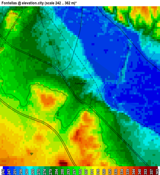
Below is the Elevation map of Fontellas, which displays elevation range with different colors. Scale of the first map is from 242 to 362 m (794 to 1188 ft) with average elevation of 282.5 meters (=927 ft) [note 1]
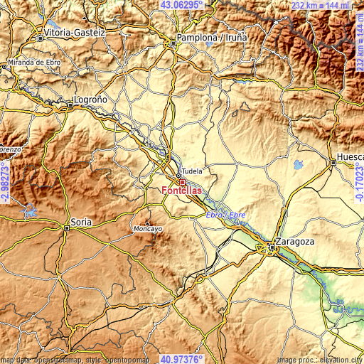
These maps also provides idea of topography and contour of this city, they are displayed at different zoom levels. More info about maps, scale and edge coordinates you can find below images.
| \ | Map #1 | Topo.Map |
| Scale [m] | 242..362 m | × |
| Scale [ft] | 794..1188 ft | × |
| Average | 282.5 m = 927 ft | × |
| Width | 7.26 km = 4.5 mi | 232.3 km = 144.3 mi |
| Height | 7.26 km = 4.5 mi | 232.3 km = 144.3 mi |
| ↑Max Latitude | 42.059576° | 43.06295° |
| Latitude at center | 42.02694° | 42.02694° |
| ↓Min Latitude | 41.994288° | 40.97376° |
| ← Min Longitude | -1.620425° | -2.98273° |
| Longitude center | -1.57648° | -1.57648° |
| →Max Longitude | -1.532535° | -0.17023° |
Nearby cities:
Cities around Fontellas sort by population:
• Tudela elevation 266 m
4.5 km,  329°
329°
• Ribaforada 262 m
6.2 km,  121°
121°
• Murchante 323 m
6.6 km,  274°
274°
• Fustiñana 262 m
7.6 km,  95°
95°
• Buñuel 246 m
12 km, 115°
• Malón 443 m
11.4 km,  223°
223°
• Barillas 409 m
8.2 km, 215°
• Tulebras 375 m
9.9 km,  235°
235°
• Monteagudo 386 m
11.1 km,  232°
232°
• Cascante 371 m
9.2 km,  249°
249°
• Ablitas 380 m
7.9 km, 222°
• Cabanillas 260 m
4.2 km,  81°
81°
Multilingual:
 En español:
Fontellas elevación 280 m.
 En France:
Fontellas élévation 280 m.
 Auf Deutsch:
Fontellas höhe über dem Meeresspiegel ist 280 m.

Sources and notes:
- [note 1] Map square and city borders are not equal. Map elevation data is calculated only from area inside that square.
- [src 1] Elevation data from geonames database provided with same terms of usage.
- [src 2] The elevation map of Fontellas is generated using elevation data from NASA's 3 arcsec (90m) resolution SRTM data.
- [src 3] Base (background) map © OpenStreetMap contributors tiles are generated by Geofabrik and OpenTopoMap.
Copyright & License:
This Fontellas Elevation Map is licensed under CC BY-SA. You may reuse any part from this page, if you give a proper credit by linking to this URL:
 More info on terms of use page.