Buñuel elevation
Buñuel (Navarre, Provincia de Navarra), Spain elevation is 246 meters and Buñuel elevation in feet is 807 ft above sea level [src 1]. Buñuel is a seat of a third-order administrative division (feature code) with elevation that is 357 meters (1171 ft) smaller than average city elevation in Spain.
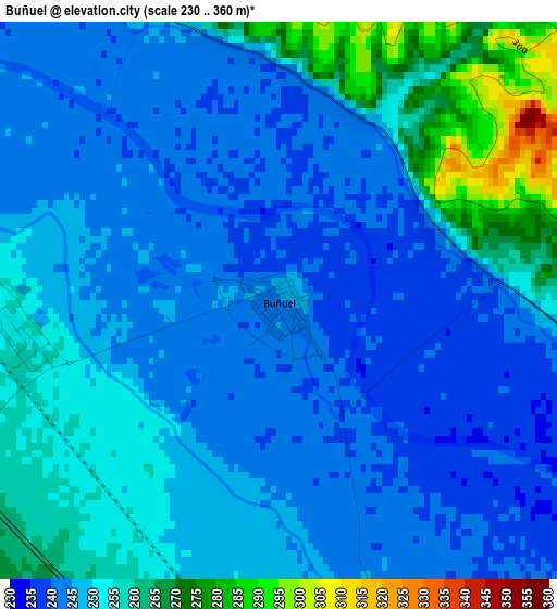
Below is the Elevation map of Buñuel, which displays elevation range with different colors. Scale of the first map is from 230 to 360 m (755 to 1181 ft) with average elevation of 249.7 meters (=819 ft) [note 1]
These maps also provides idea of topography and contour of this city, they are displayed at different zoom levels. More info about maps, scale and edge coordinates you can find below images.
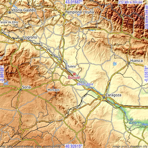
| \ | Map #1 | Topo.Map |
| Scale [m] | 230..360 m | × |
| Scale [ft] | 755..1181 ft | × |
| Average | 249.7 m = 819 ft | × |
| Width | 7.26 km = 4.5 mi | 232.5 km = 144.5 mi |
| Height | 7.26 km = 4.5 mi | 232.5 km = 144.5 mi |
| ↑Max Latitude | 42.01275° | 43.01687° |
| Latitude at center | 41.98009° | 41.98009° |
| ↓Min Latitude | 41.947414° | 40.92615° |
| ← Min Longitude | -1.488975° | -2.85128° |
| Longitude center | -1.44503° | -1.44503° |
| →Max Longitude | -1.401085° | -0.03878° |
Nearby cities:
Cities around Buñuel sort by population:
• Tudela elevation 266 m
16 km,  304°
304°
• Ribaforada 262 m
5.9 km,  289°
289°
• Mallén 279 m
9.1 km,  166°
166°
• Fustiñana 262 m
5.6 km,  323°
323°
• Fontellas 280 m
12 km, 295°
• Novillas 242 m
6.7 km,  140°
140°
• Fréscano 292 m
10.8 km,  182°
182°
• Barillas 409 m
15.6 km,  264°
264°
• Agón 324 m
13.8 km, 182°
• Bisimbre 321 m
13.8 km, 179°
• Cabanillas 260 m
8.9 km,  311°
311°
• Cortes 258 m
6.7 km,  162°
162°
Multilingual:
 En español:
Buñuel elevación 246 m.
 En France:
Buñuel élévation 246 m.


Sources and notes:
- [note 1] Map square and city borders are not equal. Map elevation data is calculated only from area inside that square.
- [src 1] Elevation data from geonames database provided with same terms of usage.
- [src 2] The elevation map of Buñuel is generated using elevation data from NASA's 3 arcsec (90m) resolution SRTM data.
- [src 3] Base (background) map © OpenStreetMap contributors tiles are generated by Geofabrik and OpenTopoMap.
Copyright & License:
This Buñuel Elevation Map is licensed under CC BY-SA. You may reuse any part from this page, if you give a proper credit by linking to this URL:
 More info on terms of use page.