Malón elevation
Malón (Aragon, Provincia de Zaragoza), Spain elevation is 443 meters and Malón elevation in feet is 1453 ft above sea level [src 1]. Malón is a seat of a third-order administrative division (feature code) with elevation that is 160 meters (525 ft) smaller than average city elevation in Spain.
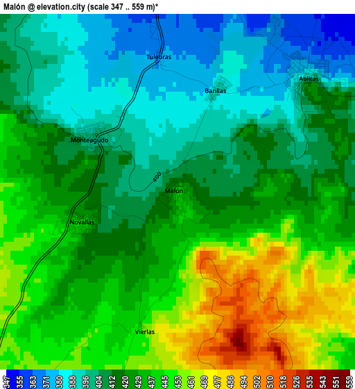
Below is the Elevation map of Malón, which displays elevation range with different colors. Scale of the first map is from 347 to 559 m (1138 to 1834 ft) with average elevation of 423.7 meters (=1390 ft) [note 1]
These maps also provides idea of topography and contour of this city, they are displayed at different zoom levels. More info about maps, scale and edge coordinates you can find below images.
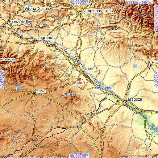
| \ | Map #1 | Topo.Map |
| Scale [m] | 347..559 m | × |
| Scale [ft] | 1138..1834 ft | × |
| Average | 423.7 m = 1390 ft | × |
| Width | 7.27 km = 4.5 mi | 232.6 km = 144.5 mi |
| Height | 7.27 km = 4.5 mi | 232.6 km = 144.5 mi |
| ↑Max Latitude | 41.985024° | 42.98959° |
| Latitude at center | 41.95235° | 41.95235° |
| ↓Min Latitude | 41.919659° | 40.89795° |
| ← Min Longitude | -1.715935° | -3.07824° |
| Longitude center | -1.67199° | -1.67199° |
| →Max Longitude | -1.628045° | -0.26574° |
Nearby cities:
Cities around Malón sort by population:
• Tarazona elevation 493 m
7 km,  220°
220°
• Murchante 323 m
8.9 km,  8°
8°
• Novallas 428 m
2.3 km,  263°
263°
• Torrellas 574 m
10.4 km,  231°
231°
• Barillas 409 m
3.6 km,  63°
63°
• Santa Cruz de Moncayo 621 m
10.5 km, 221°
• Tulebras 375 m
2.8 km,  352°
352°
• Vierlas 456 m
2.9 km,  195°
195°
• Grisel 630 m
10.2 km,  207°
207°
• Cascante 371 m
5.1 km, 351°
• Ablitas 380 m
3.6 km,  46°
46°
• Monteagudo 386 m
1.8 km,  329°
329°
Multilingual:
 En español:
Malón elevación 443 m.
 En France:
Malón élévation 443 m.


Sources and notes:
- [note 1] Map square and city borders are not equal. Map elevation data is calculated only from area inside that square.
- [src 1] Elevation data from geonames database provided with same terms of usage.
- [src 2] The elevation map of Malón is generated using elevation data from NASA's 3 arcsec (90m) resolution SRTM data.
- [src 3] Base (background) map © OpenStreetMap contributors tiles are generated by Geofabrik and OpenTopoMap.
Copyright & License:
This Malón Elevation Map is licensed under CC BY-SA. You may reuse any part from this page, if you give a proper credit by linking to this URL:
 More info on terms of use page.