Fuentesaúco elevation
Fuentesaúco (Castille and León, Provincia de Zamora), Spain elevation is 804 meters and Fuentesaúco elevation in feet is 2638 ft above sea level [src 1]. Fuentesaúco is a seat of a third-order administrative division (feature code) with elevation that is 201 meters (659 ft) bigger than average city elevation in Spain.
Below is the Elevation map of Fuentesaúco, which displays elevation range with different colors. Scale of the first map is from 756 to 915 m (2480 to 3002 ft) with average elevation of 830.5 meters (=2725 ft) [note 1]
These maps also provides idea of topography and contour of this city, they are displayed at different zoom levels. More info about maps, scale and edge coordinates you can find below images.
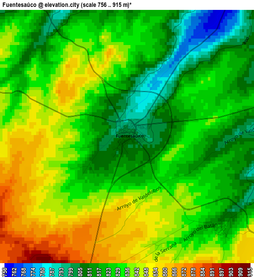
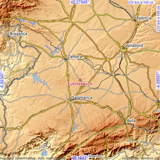
| \ | Map #1 | Topo.Map |
| Scale [m] | 756..915 m | × |
| Scale [ft] | 2480..3002 ft | × |
| Average | 830.5 m = 2725 ft | × |
| Width | 7.35 km = 4.6 mi | 235.2 km = 146.1 mi |
| Height | 7.35 km = 4.6 mi | 235.2 km = 146.1 mi |
| ↑Max Latitude | 41.263471° | 42.27945° |
| Latitude at center | 41.23043° | 41.23043° |
| ↓Min Latitude | 41.197372° | 40.1643° |
| ← Min Longitude | -5.541165° | -6.90347° |
| Longitude center | -5.49722° | -5.49722° |
| →Max Longitude | -5.453275° | -4.09097° |
Nearby cities:
Cities around Fuentesaúco sort by population:
• Fuentelapeña elevation 744 m
9.8 km,  76°
76°
• Topas 825 m
14 km,  234°
234°
• Cañizal 795 m
12.9 km,  123°
123°
• Villamor de los Escuderos 836 m
6.9 km,  290°
290°
• San Miguel de la Ribera 765 m
13.2 km,  329°
329°
• Villaescusa 828 m
3.9 km,  134°
134°
• Vadillo de la Guareña 716 m
13.4 km,  64°
64°
• Argujillo 769 m
11.8 km,  320°
320°
• Parada de Rubiales 843 m
10.5 km,  150°
150°
• Aldeanueva de Figueroa 873 m
9.4 km,  193°
193°
• Tardáguila 833 m
14.4 km,  206°
206°
• Castrillo de la Guareña 730 m
14.4 km,  90°
90°
Multilingual:
 En español:
Fuentesaúco elevación 804 m.
 En France:
Fuentesaúco élévation 804 m.
 Auf Deutsch:
Fuentesaúco höhe über dem Meeresspiegel ist 804 m.

Sources and notes:
- [note 1] Map square and city borders are not equal. Map elevation data is calculated only from area inside that square.
- [src 1] Elevation data from geonames database provided with same terms of usage.
- [src 2] The elevation map of Fuentesaúco is generated using elevation data from NASA's 3 arcsec (90m) resolution SRTM data.
- [src 3] Base (background) map © OpenStreetMap contributors tiles are generated by Geofabrik and OpenTopoMap.
Copyright & License:
This Fuentesaúco Elevation Map is licensed under CC BY-SA. You may reuse any part from this page, if you give a proper credit by linking to this URL:
 More info on terms of use page.